
Indonesia's Megathrust Zone Updated, Japanese Expert Reveals Most Dangerous Areas
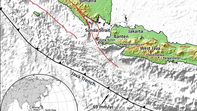
The potential for a giant earthquake looms over Indonesia, which sits on the Ring of Fire. Based on the updated 2024 Indonesian Earthquake Source and Hazard Map, the number of megathrust zones surrounding the archipelago has officially increased to 14 main points, with hazard contour mapping becoming denser and indicating higher risk. This shift in the risk map has immediately drawn international attention, including from leading Japanese scientists. Professor Kosuke Heki, a renowned geophysicist from Hokkaido University, revealed that the geological structural characteristics encircling Indonesia bear a striking resemblance to the Nankai Trough—one of the most active and closely monitored megathrust zones in Japan. “We understand that magnitude 8 earthquakes in Japan occur in intervals of about 50 to 100 years. This was our classic view before the great earthquake,” Heki stated during a scientific forum at the National Research and Innovation Agency (BRIN). According to him, Indonesia’s plate boundary regions are currently under constant pressure. Tectonic energy is creeping slowly but surely, ready to release its destructive force at any time. “We see seismic coupling that locks almost along the entire axis of the trench. Even in the very shallow parts of the plate boundary, strain is accumulating for the next earthquake,” Heki explained, describing the conditions beneath Indonesian waters. Heki also highlighted the importance of detecting the phenomenon of slow slip events. These movements do not trigger dramatic shaking instantly but serve as a crucial indicator that a major fault is preparing to rupture. In Japan, strict monitoring of slow slip events using Global Navigation Satellite System (GNSS) technology and submarine geodetic sensors forms the primary shield for disaster mitigation. He assessed that Indonesia, surrounded by active subduction zones from Sumatra, Java, Bali, West Nusa Tenggara, to Maluku, must strengthen similar infrastructure with precision. “This phenomenon has been observed repeatedly in the Nankai Trough. One of these slow slip events could potentially trigger the next great earthquake. I am currently working on this problem in Indonesia,” he added. Based on the latest data, the national earthquake hazard map places several regions at a high alert level with terrifying maximum magnitude potentials: The Aceh-Andaman Megathrust holds the largest energy potential, up to Magnitude 9.2. The Java Megathrust could trigger devastating shaking up to Magnitude 9.1. The Mentawai cluster (Siberut and Pagai) and Enggano each carry a hazard potential of up to Magnitude 8.9. Meanwhile, the Meteorology, Climatology, and Geophysics Agency (BMKG) continues to closely monitor two areas that currently hold seismic gap status—quiet zones that have not released their energy for hundreds of years. These two crucial areas are the Sunda Strait (last major earthquake in 1757) and Mentawai-Siberut (last in 1797). Despite this, BMKG has reiterated that the public should not panic excessively over narratives that it is “just a matter of time.” “What is meant is the accumulation of energy that remains stored because a large earthquake has not occurred for a long time. It does not mean an earthquake will happen in the near future,” BMKG stressed in its official statement. The public is urged to continuously improve independent mitigation capacity and not to blindly swallow hoax news that predicts a specific date for an earthquake.