
Indonesia's Megathrust Zone Map Updated, Japanese Expert Points to Danger Areas
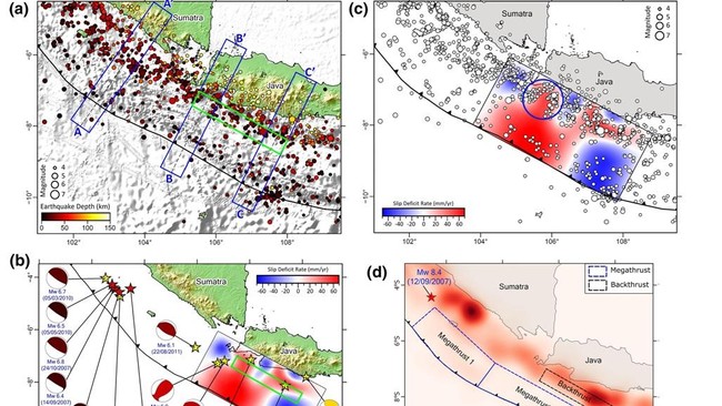
The risk of major earthquakes in Indonesia has come back into the spotlight following the update of the 2024 Indonesia Earthquake Source and Hazard Map, which records an increase in the number of megathrust zones to 14 points. The latest map shows a higher potential for danger compared to the 2017 release, characterised by increasingly dense hazard contours in several regions.
The increase in megathrust zones in Indonesia has also drawn attention from Japan. Professor Kosuke Heki from Hokkaido University assesses that Indonesia’s geological character shares similarities with the Nankast Trough zone, one of the most active megathrust regions in the world.
“We understand that magnitude 8 earthquakes in Japan occur at intervals of approximately 50 to 100 years. This is our classic view before a major earthquake occurs,” said Heki while serving as a Visiting Researcher at the National Research and Innovation Agency (BRIN) in late December 2025.
According to Heki, although the timing of major earthquakes is difficult to predict, long-term monitoring of Earth’s crustal deformation is a vital key in disaster mitigation. He emphasised the role of the Global Navigation Satellite System (GNSS) and seabed geodetic measurements in reading stress accumulation in subduction zones.
“We observe seismic coupling that is locked almost along the axis of the trench. Even at very shallow plate boundary sections, strain continues to accumulate for the next earthquake,” he explained.
Heki also highlighted the phenomenon of ‘slow slip events’ or slow shifts that frequently appear before major earthquakes. Despite moving very slowly, this phenomenon is considered a potential early indicator.
“This phenomenon has been observed repeatedly in the Nankai Trough and other regions in Japan. One of these slow slip events could potentially trigger the next major earthquake,” he said.
He believes Indonesia has a great opportunity to develop similar monitoring systems, given the many active subduction zones ranging from Sumatra, Java, Bali, and Lombok to Maluku. By strengthening the GNSS network and seabed monitoring technology, Indonesia is considered capable of reading tectonic stress accumulation more precisely.
“Currently, I am working on this issue in Indonesia,” said Heki.
In the latest map, the Aceh-Andaman megathrust zone is recorded as having the greatest earthquake potential, with a maximum magnitude reaching 9.2. Meanwhile, the Java Megathrust has the potential to trigger earthquakes up to magnitude 9.1. Several other zones, such as Mentawai-Siberut, Mentawai-Pagai, and Enggano, each hold earthquake potential of up to magnitude 8.9.
The Meteorology, Climatology, and Geophysics Agency (BMKG) previously highlighted the existence of two megathrust zones that remain in a ‘seismic gap’ condition, namely the Sunda Strait and Mentawai-Siberut. Both regions have not released significant energy for hundreds of years, since the last earthquakes in 1757 and 1797, respectively.
BMKG emphasised that the term “waiting for time” is not intended as a prediction of when an earthquake will occur.
“What is meant is the accumulation of energy that remains stored because a major earthquake has not occurred for a long time. It does not mean an earthquake will occur in the near future,” BMKG wrote in an official statement.