
Indonesian Forest and Land Fires So Severe They Have Caught NASA's Attention
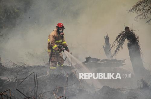
Forest and land fires in Indonesia have become so severe that the United States’ National Aeronautics and Space Administration (NASA) has taken notice. NASA even published a special article illustrating the darkened skies over Indonesia caused by these fires.
“NASA satellite imagery depicts smoke enveloping Indonesia and Malaysia on 1 September 2026. Red dots have been added where instruments from the MODIS satellite detected indications of heat anomalies from fires,” stated NASA in a post on its X account, @NASAEarth, accompanied by satellite photography.
According to NASA’s report, the fires occurring in Indonesia are taking place on wetlands that have dried out. These fires burn slowly, produce high levels of pollution, and are notoriously difficult to extinguish because they smoulder at low temperatures, often burning beneath thick layers of peat deposits.
NASA estimates that burning peat produces three times more particulate matter than tropical forest fires, five times more sulphur oxides, three times more organic carbon, and twice as much methane and carbon monoxide.
Peat fires present a significant challenge for Indonesia, which hosts 36 per cent of the world’s total tropical peatlands. As peat dries out during prolonged dry seasons, Indonesia’s peatland landscapes have become fire zones at various points over the last three decades, producing blankets of smoke that persist for weeks and disrupt the lives of millions.
During annual fire seasons in Indonesia—such as those during the previous El Niño events in 1997 and 2015—fires have produced extreme heat in recent decades. Climate patterns, currently assessed by NOAA satellites and intensifying in August, typically trigger a sharp reduction in rainfall across Indonesia.
“Indonesia has only been in its fire season for three weeks, but we are seeing fire activity accelerating sharply, similar to 2015,” said Robert Field, a researcher from Columbia University.
“A strong El Niño makes the dry season drier across Indonesia’s most vulnerable regions and exacerbates the fires, just as we anticipated would happen,” added Field.
In 2015, after fires raged for more than three months, Indonesia released 1.75 billion tonnes of greenhouse gases. As of 2 September, this year’s fires in Indonesia have been active for approximately one month and have already released about 10 per cent of the amount seen during the 2015 fires.
Similar to 2015, Indonesia is currently experiencing severe and widespread drought conditions. According to BMKG data, approximately 90 per cent of Indonesia’s total area received little rain in early August. Normally, conditions are too wet for fire to spread through underground peat deposits in Kalimantan, Sumatra, and Papua, but spread can occur under dry conditions.
“Surface fires are less of a concern, but when fire spreads underground, it will not stop spreading,” said Field.
“The fire will continue to smoulder until the rains arrive in October or November.”
Source: jawawa.id (https://jawawa.id/newsitem/indonesian-forest-and-land-fires-so-severe-they-have-caught-nasas-attention-1788515884)
Originally published by Republika (https://news.republika.co.id/berita/tku0nw409/kebakaran-hutan-dan-lahan-di-indonesia-sebegitu-parahnya-sampai-disorot-nasa), translated from Indonesian