
Here's How to Track the Spread of Volcanic Ash from Mount Anak Krakatau Using Your Phone
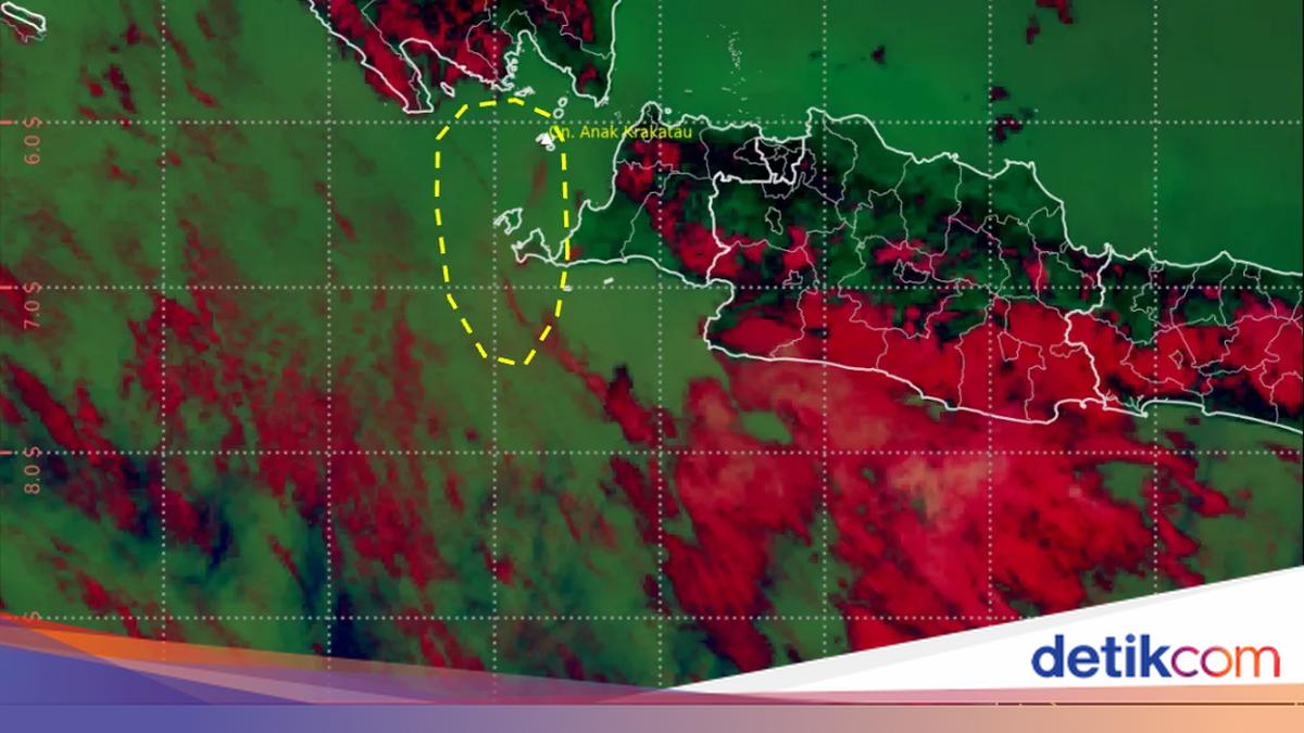
The spread of volcanic ash from the eruption of Mount Anak Krakatau can be monitored online through a number of satellite imagery-based services. This information can help the public understand the direction of movement and the areas potentially affected.
Several services provide satellite imagery displays that are updated periodically. There are also official government channels that can serve as references for obtaining the latest information. Here is how to monitor the spread of volcanic ash from Mount Anak Krakatau online via smartphone.
- Monitor BMKG Satellite Imagery
The BMKG’s Volcanic Ash Dispersal Imagery page provides satellite imagery that specifically shows the analysis of ash dispersal from Mount Anak Krakatau. This product is produced based on information from PVMBG and VAAC Darwin.
The data on the page is updated periodically so the public can see the latest developments in the ash dispersal. The affected areas are also displayed on the imagery to make monitoring easier.
Here are the steps:
Open the BMKG Volcanic Ash Dispersal Imagery page
Select or search for the area you wish to monitor
Check the latest imagery available on the page
Observe the ash dispersal area marked with a yellow polygon
Note the direction and areas included in the dispersal zone
- Use NASA Worldview
Another way to view atmospheric conditions from satellite imagery is through NASA Worldview. This service allows users to view various satellite imagery interactively and select specific observation times.
Here are the steps:
Open the NASA Worldview page
Search for the location of Mount Anak Krakatau or direct the map to the Sunda Strait region
Select the Add Layers menu to add imagery layers
Choose the type of satellite imagery available
Set the date and time using the timeline
Compare imagery from different times to see changes in conditions in the region
- Information from Official Channels
Monitoring the spread of volcanic ash can also be done by following information from the official channels of BMKG, the Geological Agency/PVMBG, and BNPB. Each agency has information related to weather and atmospheric conditions, volcanic activity, and disaster impact handling.
Here are the steps:
Open the official website or social media accounts of:
PVMBG/Geological Agency
BMKG
BNPB/local BPBD - Look for updated information about Mount Anak Krakatau
Pay attention to the publication time of the information to get the latest data
Follow the advisories issued by the relevant agencies
Latest Ash Dispersal from Anak Krakatau
Based on BMKG volcanic ash dispersal imagery on Tuesday, 8 September 2026 at 13.00 WIB, analysis of Himawari-9 RGB imagery referring to information from PVMBG and VAAC Darwin identified the spread of volcanic ash from Mount Anak Krakatau.
The ash dispersal was identified up to a height of around 7,000 feet or 2.1 kilometres. According to the imagery, the volcanic ash was moving towards the south-west.
The dispersal area covers part of south-western Banten and the Indian Ocean to the south-west of Banten. Ash dispersal conditions may change depending on eruption activity as well as wind direction and speed.
Therefore, the public is advised to monitor updates to satellite imagery and information from official agencies regularly, especially when carrying out activities or travelling in areas potentially affected by volcanic ash.
Source: jawawa.id (https://jawawa.id/newsitem/heres-how-to-track-the-spread-of-volcanic-ash-from-mount-anak-krakatau-using-your-phone-1788854014)
Originally published by detikcom (https://news.detik.com/berita/d-8653785/begini-cara-pantau-sebaran-abu-vulkanik-gunung-anak-krakatau-pakai-hp), translated from Indonesian