
Geological Agency Urges EWS and Sabo Dams to Mitigate Flood Risks in Solok
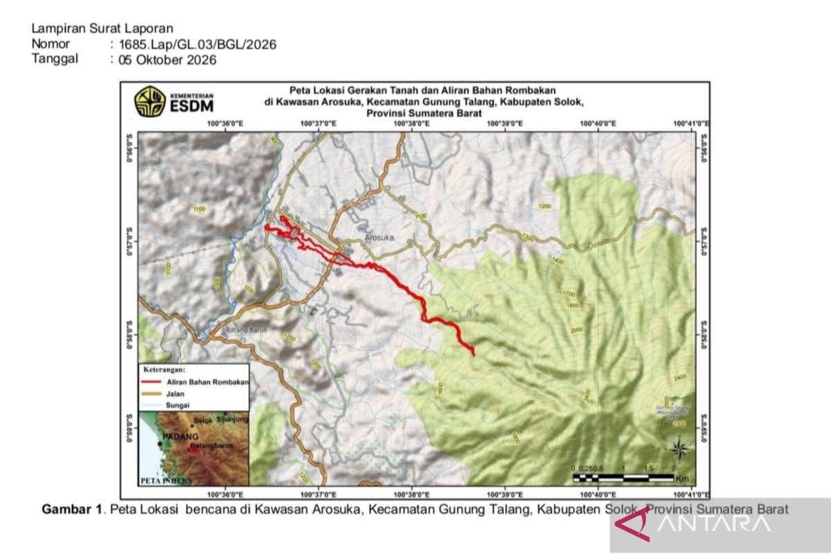
Jakarta (ANTARA) - The Geological Agency of the Ministry of Energy and Mineral Resources (ESDM) has requested that the construction of an integrated early warning system (EWS) and the implementation of sediment control structures (sabo dams) in Solok, West Sumatra, be prioritised to reduce the risk of flash floods.
Lana Saria, Head of the Geological Agency, stated in Jakarta on Monday that these recommendations are urgently needed along the river basin (DAS) of the western slopes of Mount Talang, which traverses the Arosuka area.
“The early warning system that is built must be connected to upstream rainfall monitoring, changes in water discharge, and the potential for river channel blockages in real-time,” she said.
She added that the development of the EWS also needs to be equipped with the establishment of safe rainfall thresholds, as well as standard operating procedures (SOP) for evacuating residents and closing main access roads during extreme weather.
However, she emphasised that the planning of sabo dams must be preceded by in-depth studies regarding hydrology, sedimentology, and geotechnics to ensure their storage capacity is precise relative to the potential volume of subsequent landslides.
The Geological Agency hopes these technical steps can protect residential areas, office complexes, and the vital Solok-Padang route from the threat of recurring material floods in the future, following the evaluation of the flash flood event on 21 September.
The Geological Agency’s investigation team reported that the flash flood in the Arosuka area, Solok Regency, West Sumatra, was triggered by a combination of heavy rain and the blockage of landslide material on the western slopes of Mount Talang.
Landslide material consisting of soil, volcanic rock, and andesite boulders measuring 2 to 3 metres entered the river channel and accumulated at the junction of two main valleys.
The accumulation of this material is strongly suspected to have formed a natural dam that temporarily blocked water flow upstream, leading to large volumes of water accumulation.
“The collapse of this natural dam then suddenly released water and debris at high speed and energy down the valley towards the residential areas and office complexes of Arosuka,” said Lana.
According to her, the situation was further exacerbated by the extreme elevation difference between the upstream and downstream areas, reaching 1,325 metres, which provided immense gravitational energy for the movement of the material flow.
Geological studies also noted that pyroclastic material and weathered soil on the slopes of Mount Talang, which have not yet been well-consolidated, are very easily eroded and dissolved when experiencing increased moisture levels.
The river system in the Arosuka area, which features a convergence pattern of several tributaries, eventually overflowed downstream approximately 8 kilometres from the centre of the upstream landslide.
Source: jawawa.id (https://jawawa.id/newsitem/geological-agency-urges-ews-and-sabo-dams-to-mitigate-flood-risks-in-solok-1791202079)
Originally published by Antara (Indonesian) (https://www.antaranews.com/berita/5772113/badan-geologi-dorong-ews-dan-sabo-dam-atasi-risiko-banjir-di-solok), translated from Indonesian