
Forest Fires Persist in Bromo, Semeru, Argopuro, and Kawinajang
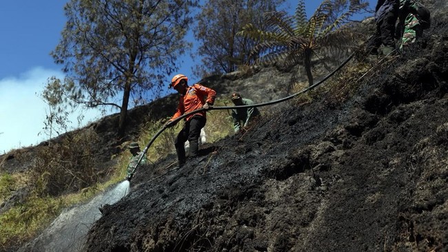
The National Disaster Management Agency (BNPB) reported that efforts to manage forest and land fires (karhutla) are still underway in several mountainous areas of East Java as of Sunday (13/09/2026) at 18:00 WIB. Joint teams continue to conduct firefighting, wetting, monitoring, and aerial observations to control hotspots and prevent the spread to other areas.
The Acting Head of the BNPB Disaster Data, Information, and Communication Centre, Berton SP Panjasting, stated that steep terrain, limited access, fog, and strong winds have become several obstacles to field operations.
In the Mount Bromo area, Probolinggo Regency, plumes of smoke are still visible in the Gunung Kursi area and around Jemplang. According to the Bromo Tengger Semeru National Park (BB TNBTS), the fire was first detected on Thursday (10/09) at 16:30 WIB in the Savana Pengol area, before spreading towards Gunung Kursi.
On Saturday (12/09), flames reappeared in the Pengol area and, due to strong winds, moved to the Jemplang Post around 16:20 WIB. As of Sunday (13/09), joint teams are still conducting firefighting and wetting via land routes in accessible locations, while water bombing operations cannot yet be performed due to ongoing strong winds.
To support the management efforts and ensure visitor safety, BB TNBTS has closed all tourist visits to Mount Bromo from all entry points since Saturday (12/09) until further notice.
In the Mount Semeru area, Lumajang Regency, aerial observations on Saturday (12/09) using the PK-DAP Helicopter showed continued plumes of smoke, with new hotspots detected around Post 3 of the hiking trail.
Joint teams via land routes have extinguished embers at the Watu Rejeng Post to ensure they are completely out and to prevent potential spread to lower areas. Hotspots around Post 3 cannot yet be addressed directly due to the steep terrain, so progress is being monitored from Watu Rejeng Post and Post 2.
In the Mount Argopuro area, Jember Regency, plumes of smoke are still visible, with several hotspots located on difficult-to-reach slopes, specifically at Gunung Gilap and Cikasur, Aeng Kenek in the Cemara Lima Area, and Gunung Pinggang. Joint teams are performing manual firefighting using the ‘gepyok’ method in the Aeng Kenek area, while fog covering the area necessitates continuous monitoring. Perhutani KPH Jember is also conducting patrols and monitoring in the location.
Meanwhile, in the Mount Kawinajang area, Blitar Regency, aerial observations using the PK-DAP Helicopter on Sunday (13/09) showed thick plumes of smoke, with hotspots moving towards the Gunung Butak Savanna, Dau District, Malang Regency. The East Java Provincial BPBD, along with the Blitar and Malang Regency BPBDs, continue to conduct assessments and monitor the development of hotspots and the surrounding area.
BNPB confirmed that as of Sunday (13/09) at 18:00 WIB, there have been no reports of fatalities due to the forest fires in these locations, while the impact is still being assessed. Joint teams are said to be continuously adjusting their response based on terrain conditions, weather, access to locations, and personnel safety.
BNNP urges the public not to approach the fire locations and to comply with official instructions, including the closure of tourist areas. The public is also requested to avoid activities that could trigger fires and to immediately report any hotspots or smoke plumes to officials or local governments.
Source: jawawa.id (https://jawawa.id/newsitem/forest-fires-persist-in-bromo-semeru-argopuro-and-kawinajang-1789314887)
Originally published by CNBC Indonesia (https://www.cnbcindonesia.com/news/20260913213242-4-767553/karhutla-masih-terjadi-di-bromo-semeru-argopuro-dan-kawinajang), translated from Indonesian