
Forest Fire Hotspots Decrease, Government Strengthens Ground Operations in Kalimantan
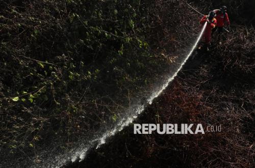
The number of high-confidence hotspots nationwide has decreased by 588 points to 344 points as of Wednesday (23/09/2026). Nevertheless, the government continues to strengthen the management of forest and land fires (karhutla), particularly through ground operations in South Kalimantan and other priority regions.
Based on SiPongi data from the Ministry of Forestry, sourced from NASA Terra/Aqua, SNPP, and NOAA-20 satellites, 344 high-confidence hotspots were detected until Wednesday (23/09) at 21:05 WIB. This figure is a decrease from 932 points recorded on Tuesday (22/09).
In a press release on Thursday (24/09/2026), the Ministry of Forestry stated that across six priority provinces, high-confidence hotspots were recorded at 156 points in Central Kalimantan, 33 in West Kalimantan, 11 in South Kalimantan, 4 in South Sumatra, 2 in Jambi, and zero in Riau.
Overall, the number of hotspots in the six priority provinces dropped from 778 to 206 points within a single day. Central Kalimantan recorded the largest decrease but remains the province with the highest number of hotspots among the six regions.
The Ministry of Forestry reminded that hotspots are indications of surface temperature anomalies detected by satellites and cannot be immediately equated to actual fire incidents or the total area burned. Every indication requires verification through ground checks and monitoring of actual field conditions.
After monitoring fire management in Central Kalimantan, Minister of Forestry Raja Juli Antoni, alongside the Head of BNPB, Lieutenant General TNI Suharyanto, continued monitoring in South Kalimantan on Wednesday (23/09).
The two officials inspected the firefighting process in the peatland area near the Sambang Lihum Psychiatric Hospital in Banjar Regency, while also participating in an evaluation of fire management alongside local governments, the TNI, Polri, BPBD, and other relevant agencies.
The evaluation focused on strengthening ground operations, synchronising field data, and the deployment of personnel and resources to locations still requiring intervention. The Banjar Regency Government is also preparing additional personnel to bolster operations in high-risk areas.
Ground operations are crucial in managing peatland fires because embers can persist beneath the surface even when flames are no longer visible. Consequently, wetting and cooling processes are being continuously carried out to prevent the fire from resurfacing.
In addition to ground operations, the government has deployed 61 aerial units to support fire management. 17 units are being used for patrols and Weather Modification Operations (OMC), while 44 units are dedicated to water bombing.
The operation of aerial fleets takes into account the development of hotspots, potential cloud cover, wind direction, smoke conditions, visibility, and flight safety.
On the ground, the Manggala Agni of the Ministry of Forestry, alongside BNPB, TNI, Polri, BPBD, local governments, the community, volunteers, the business sector, and related parties, are conducting patrols, ground checks, direct firefighting, fire containment, wetting, mopping up, and cooling.
Meanwhile, air quality conditions in several regions of Sumatra and Kalimantan still require vigilance. PM2.5 monitoring shows that most areas are in the good to moderate category, but several areas remain in the unhealthy to very unhealthy category, with some locations even reaching the hazardous category.
BMKG Aviation monitoring in the early hours of Thursday (24/09) showed that smoke is still affecting visibility in several priority regions. Visibility in Palangka Raya and Pontianak is approximately 1.5 kilometres, Banjarmasin around 3 kilometres, Jambi and Palembang around 5 kilometres, and Pekanbaru around 6 kilometres under light rain conditions.
The decrease in the number of hotspots does not necessarily mean all fires have been extinguished or that air quality has immediately recovered. Existing smoke can still move according to wind and atmospheric conditions, while embers in peatlands can remain active beneath the surface.
The Ministry of Forestry urges residents in affected areas to follow information regarding air quality and directions from local governments. When air quality worsens, the public is advised to reduce outdoor activities and use masks if they must be outside.
The public and business actors are also reminded not to clear land using burning methods. If smoke, hotspots, or burning activities are detected, the community is requested to report them immediately to officials so that intervention can be carried out as early as possible.
Source: jawawa.id (https://jawawa.id/newsitem/forest-fire-hotspots-decrease-government-strengthens-ground-operations-in-kalimantan-1790240296)
Originally published by Republika (https://esgnow.republika.co.id/berita/tluyrm416/hotspot-karhutla-turun-pemerintah-perkuat-operasi-darat-di-kalimantan), translated from Indonesian