
Forest and Land Fires: Jambi Provincial DPRD Ensures Embers are Extinguished and Peatlands Rehydrated
Jambi – The Deputy Chairman of the Jambi Provincial DPRD, Ir. H. Ivan Wirata, has reminded local governments and the Forest and Land Fire Task Force not to be hasty in scaling back operations after daily hotspot counts showed a sharp decline in early September 2026.
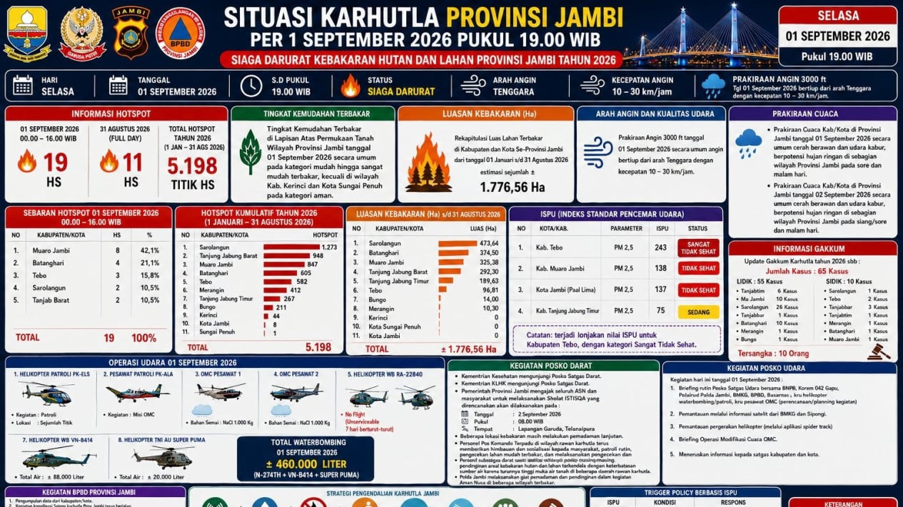
According to the daily report from the Jambi Province Forest and Land Fire Task Force as of 1 September 2026, at 19:00 WIB, only 19 hotspots were monitored until 16:00 WIB, following 11 hotspots recorded on 3ly August. However, the report noted an accumulated total of 5,198 hotspots for 2026, with an estimated burnt area of 1,776.56 hectares.
The burnt area of 1,776.56 hectares was also confirmed in coordination meetings between local governments and recent news reports. Government data identifies Sarolangun as the region with the largest burnt area, followed by Batanghari, Muaro Jambi, and Tanjung Jabung Barat.
“The decrease in hotspots is good news, but it should not be interpreted as the work being finished. We are actually entering a very decisive phase: ensuring that the embers are truly extinguished, the land does not burn again, the peatlands become wet again, and the air quality returns to being healthy,” he stated.
Ivan noted that the evaluation of forest and land fires should not rely solely on daily hotspot figures.
According to government data up to the end of August, the total burnt area reached 1,776.56 hectares. Sarolangun recorded approximately 473.64 hectares, Batanghari 374.50 hectares, Muaro Jambi around 325 hectares, Tanjung Jabung Barat 292.30 hectares, and Tanjung Jabung Timur 189.63 hectares.
“Hotspots can decrease within days, but burnt land does not automatically recover. Therefore, September must be a month for cooling, rewetting, and recovery,” he explained on Tuesday, 1 September 2026.
Ivan also requested that the government strengthen the methodology for measuring fire areas. This is considered vital because there are discrepancies between government data and analyses from non-governmental parties regarding the extent of forest fires in Jambi.
In his view, these differences should be addressed through methodological transparency, field verification, and accountable spatial mapping.
Ivan’s warning aligns with statements from the Jambi Provincial BPBD (Regional Disaster Management Agency) that several fire locations have entered the cooling stage, but peatland areas must still be guarded because heat and embers beneath the surface can cause fires to resurface.