
Forest and land fires in West Kalimantan reach 38,310 hectares by August
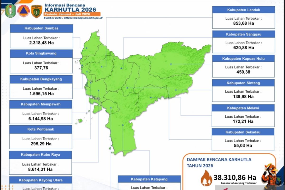
The West Kalimantan Regional Disaster Mitigation Agency (BPBD) has recorded that forest and land fires (karhutla) across the province have burned 38,310.86 hectares from January to August 2026.
“The area affected by forest and land fires up to today, from January, has reached 38,310.86 hectares,” said Daniel, Daily Coordinator of the Disaster Management Operations Control Centre (Pusdalops) at BPBD West Kalimantan, in Pontianak on Friday.
Daniel said the figure represents the latest development in the total burned area up to August 2026.
He said several regencies are of serious concern because they have recorded significant fires and are contributing to the emergence of haze.
“There are actually several regencies where the fires are quite severe and very significant in contributing smoke, including Ketapang Regency with 12,443 hectares, Kubu Raya with 8,614 hectares, Mempawah with 6,144 hectares, and Sambas with 2,318 hectares. These areas are generally peatland,” he said.
One measure taken has been to declare an emergency alert status for haze disaster at the provincial level, based on alert statuses already established in several regencies and cities.
“At least in West Kalimantan there are nine regencies that have already declared an alert status,” he said.
Previously, the West Kalimantan provincial government also held a preparedness roll call to check the readiness of personnel, equipment and supporting facilities for haze disaster management operations caused by forest and land fires.
BPBD is also running integrated ground patrols involving various elements, including the Indonesian National Armed Forces (TNI), the National Police (Polri), the Forest and Land Fire Brigade of the Forest Management Unit (UPT KPH), Manggala Agni, private companies, Fire Care Communities (MPA), disaster-resilient villages, and relevant agencies.
“The support includes patrol helicopters to monitor the distribution of hotspots and fire spots that are not detected through ground patrols, as well as water bombing helicopters and weather modification operations,” he said.
Daniel said weather modification operations have been carried out since April 2026. However, their implementation depends on atmospheric conditions and the potential for cloud growth that allows seeding.
“Weather modification operations cannot be carried out arbitrarily. They are based on forecasts from BMKG on whether there is potential for clouds that can be seeded with salt and potentially produce rain. If not, it cannot be done,” he explained.
With the burned area now exceeding 38,000 hectares, BPBD West Kalimantan continues to optimise its response through ground patrols, aerial monitoring, firefighting, and weather modification operations depending on atmospheric conditions.
Source: jawawa.id (https://jawawa.id/newsitem/forest-and-land-fires-in-west-kalimantan-reach-38-310-hectares-by-august-1787298996)
Originally published by Antara (Indonesian) (https://www.antaranews.com/berita/5704927/luas-karhutla-kalbar-mencapai-38310-hektarehingga-agustus), translated from Indonesian