
Forest and Land Fires in West Aceh Expand to 34.1 Hectares, Bubon District Worst Hit
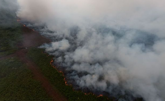
The West Aceh Regency Regional Disaster Management Agency (BPBD) has reported an increasingly alarming escalation of forest and land fires (karhutla). As of Thursday afternoon (11/6), the total area of scorched land reached 34.1 hectares, up from the 31.1 hectares reported on Thursday morning. Plt Head of BPBD West Aceh, Teuku Ronal, revealed that Bubon District is the worst affected area, with a total burned area of 25 hectares. ‘As of this afternoon, the total area affected by forest and land fires has reached 34.1 hectares. The worst-hit area is in Bubon District,’ said Teuku Ronal in Meulaboh. The first hot spots were detected gradually from the end of May through the Lancang Kuning and SiPongi+ applications. In response to the expanding conditions, a joint team has been conducting ground firefighting consistently since 31 May 2026. Given that several hot spots are in hard-to-reach areas, the National Disaster Management Agency (BNPB) has deployed Weather Modification Operations (OMC) which took place from 3 to 10 June 2026. In addition, water bombing operations using BNPB helicopters have also been intensified since 7 June to break the chain of fire spread. The firefighting operation involves cross-sector collaboration, including TNI/Polri personnel (West Aceh Military District Command and Resort Police), the Woyla Fire Station, KPH IV, student volunteers from the Teuku Umar University PK UKM, and the local community. ‘The joint team will remain on standby at the location until all hot spots are completely extinguished,’ Teuku Ronal stressed. Based on BMKG data as of 11 June 2026 at 20:40 WIB, weather conditions in the surrounding area were observed to be clear with temperatures reaching 27 °C. These dry weather conditions demand high vigilance to prevent the emergence of new hot spots on fire-prone peatlands.