
Forest and Land Fires in Six Provinces Unresolved, BNPB: Weather Modification Hindered, Water Sources Dry
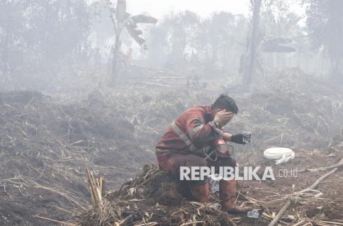
The National Disaster Mitigation Agency (BNPB) has recorded thousands of hotspots from forest and land fires (karhutla) spread across six provinces. The ecological disaster occurring in Sumatra and Kalimantan has still not been fully resolved.
Acting Head of the BNPB Data, Information, and Disaster Communication Centre, Berton SP Panjaitan, said there are a number of obstacles in handling the fires in the six priority provinces. One is the weather and climate conditions that allow fire to spread quickly and are difficult to extinguish.
“The dry air humidity and days without rain make it difficult for us to handle the fire and easy for it to spread, and we cannot easily carry out weather modification operations (OMC) because there are no cloud seeds in the atmosphere,” he said during an online press conference on Tuesday (25/8/2026).
He added that ground operations are also hampered by accessibility and limited water availability. According to him, this means personnel must work hard to extinguish fires through ground operations.
“Meanwhile, the available water has relatively receded, the water on the surface in some watercourses,” said Berton.
Moreover, the characteristics of the burned land also mean extinguishing cannot be done quickly. This is because some of the burned areas are peatland.
He explained that peatland is young coal that is difficult to extinguish when burning. This is because fire on peatland almost certainly spreads to the lower layers. This means extinguishing is not enough just by putting out the surface fire, but also requires cooling with a substantial amount of water.
“If cooling is not carried out, perhaps 1 or 3 hours, 5 hours later, the fire that has been extinguished on the surface will burn again because of the nature of peat,” he said.
On the other hand, the resulting smoke haze also makes air operations difficult. The haze causes limited visibility, so flights are not easy to continue.
“This will certainly also make it difficult when water bombing is to be carried out,” he said.
Nevertheless, Berton said his agency continues to make efforts to handle the situation. One is by attempting weather modification operations when there are cloud seeds in the atmosphere, making it possible for artificial rain to occur.
His agency also continues to strengthen water supplies by constructing new wells, retention basins, and canals. This is in line with the direction of President Prabowo Subianto. In addition, his agency has provided water tanker trucks and flexible tanks.
“So these flexible tanks can be more easily moved from one place to another,” he said.
He also hopes the business community can participate by deploying personnel and equipment for forest and land fire handling. In this way, handling in the field can become more massive.
On the other hand, the government is said to continue enforcing the law against perpetrators of burning. This is done so that no party deliberately sets fires that cause forest and land fires.
“We convey that law enforcement is still being carried out by the relevant ministries and agencies, so that going forward these law enforcement actions serve as a deterrent against burning,” he said.
Based on BNPB data as of Tuesday afternoon, forest and land fires are still occurring in six provinces: South Sumatra, Riau, Jambi, West Kalimantan, Central Kalimantan, and South Kalimantan. The data on hotspots and burned area in each province is as follows:
South Sumatra: 1,517 hotspots; burned area more than 1,926 hectares; visibility 7 km.
Riau: 447 hotspots; burned area more than 15,736 hectares; visibility 3.5 km.
Jambi: 253 hotspots; burned area more than 379 hectares; visibility 1 km.
West Kalimantan: 1,836 hotspots; burned area more than 36,310 hectares; visibility 2.5 km.
Central Kalimantan: 1,396 hotspots; burned area 7,634 hectares; visibility more than 10 km.
South Kalimantan: 473 hotspots; burned area more than 8,019 hectares; visibility above 10 km.
Total for the six provinces: 5,922 hotspots and an indicated burned area of more than 70,004 hectares.