
Expert Explains Viral Social Media Concerns Regarding Megathrust
Issues regarding the potential for megathrust earthquakes have resurfaced as a trending topic on social media. The Geological Agency of the Ministry of Energy and Mineral Resources (ESDM) explained that a megathrust is a meeting zone between two tectonic plates, where one plate subducts beneath another.
Supartoyo, a Senior Principal Earth Investigator at the Geological Agency of the Ministry of ESDM, stated that megathrust zones have the potential to be sources of earthquakes with magnitudes reaching 8 or more. “So, a megathrust is actually a zone, a meeting place between two different types of plates, where one plate subducts beneath the other. The meeting point at the upper part, with a depth of less than 50 kilometres, is what is called a Megathrust,” Supartoyo said, as quoted from the Geological Agency’s Instagram account on Monday (28/09/2026).
According to him, the term megathrust itself is derived from two words: ‘mega’, meaning large, and ‘thrust’, meaning thrust fault. Thus, a megathrust is an earthquake source capable of producing earthquakes with a magnitude of 8 or higher.
Supartoyo revealed that the issue regarding megathrusts is not new. Discussions regarding the potential for megathrust earthquakes have repeatedly emerged since the 2004 Aceh earthquake and tsunami. “I remember it initially started after the 2004 Aceh earthquake and tsunami. From 2005 until now, it has recurred repeatedly and always causes panic. Therefore, what is needed is an increase in public understanding and knowledge regarding the Megathrust,” he said.
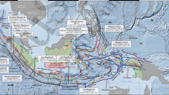
Based on Indonesia’s geotectonic maps, megathrust zones are spread across several regions in Indonesia. These include the west of Sumatra, south of Java, south of Bali, Nusa Tenggara, northern Sulawesi, northeast Sulawesi, and the northeast of Halmahera.
These areas are known to possess megathrust zones capable of producing earthquakes with magnitudes of 8 or more. Notable large-scale seismic events related to these zones include the 2004 Aceh earthquake and the 2005 Nias earthquake, which reached a magnitude of 8.5.
“So, these are the areas suspected of having Megathrust zones capable of producing earthquake magnitudes of 8 or greater than 8. Examples include what happened in Aceh in 2004, and also what occurred on Nias Island in 2005 with a magnitude of 8.5,” he said.
Nevertheless, Supartoyo emphasised that earthquakes cannot yet be predicted with absolute accuracy, specifically regarding when they will occur, their exact location, or their precise magnitude. “Although several methods aimed at this are being implemented, the results are not yet encouraging. However, through science and technology, we can identify areas prone to earthquakes and tsunamis, which the Geological Agency of the Ministry of ESDM refers to as Earthquake Disaster Prone Areas (KRBG) and Tsunami Disaster Prone Areas,” he concluded.