
ETLE Drone Patrol Presisi Deployed on MT Haryono to Support AI-Based Traffic Management
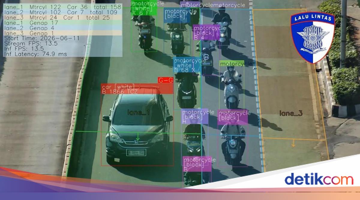
The Traffic Corps of the Indonesian National Police (Korlantas Polri) is continuing to develop the use of the ETLE Drone Patrol Presisi as part of a digital transformation in traffic management. Beyond serving as an electronic law enforcement tool, the drone is now being utilised to support traffic supervision and rapid, accurate decision-making in the field.
The ETLE Drone Patrol Presisi was flown over the MT Haryono area in South Jakarta on Thursday morning (11/6/2026) to monitor traffic flow from the air. Unlike standard law enforcement operations, this deployment focused on observing vehicle density and assisting officers in determining traffic engineering measures should vehicle volumes increase or potential congestion arise.
Through real-time aerial monitoring, officers gain a comprehensive picture of traffic conditions, including density levels, points of slowing traffic, and potential vehicle queues on the monitored roads. This information serves as the basis for officers to decide on contingency plans or traffic engineering required to disperse congestion and maintain public mobility.
One of the key advantages of the ETLE Drone Patrol Presisi is its ability to perform automatic traffic counting, or vehicle volume calculation. This feature allows officers to obtain accurate, real-time data on the number of passing vehicles, enabling a more comprehensive and data-driven analysis of traffic conditions.
Kakorlantas Polri Inspector General Agus Suryonugroho stated that the use of the ETLE Drone Patrol Presisi is part of the Traffic Corps’ effort to deliver a modern traffic management system that is adaptive to technological developments. He noted that data obtained from aerial monitoring can support rapid and precise traffic policy-making, particularly on roads with high vehicle mobility.
Meanwhile, Brigadier General I Made Agus Prasatya, Director of Law Enforcement at Korlantas Polri, emphasised that the ETLE Drone Patrol Presisi represents a technological leap in supporting modern traffic management. In addition to its electronic law enforcement capabilities, the drone can present accurate, real-time traffic counting data, allowing officers to map vehicle density, identify slowdown points, and determine the most effective traffic engineering patterns. He added that decisions based on actual aerial data will accelerate officers’ response in dispersing congestion while improving the quality of service to road users.
The use of the ETLE Drone Patrol Presisi as a technology-based traffic monitoring instrument is expected to support the creation of security, safety, order, and smooth traffic flow. With accurate, real-time data, officers can take faster and more precise steps to anticipate and disperse traffic congestion in various areas, particularly on roads with high vehicle mobility.