
Environment Minister: Geospatial Data Is More Than a Map — It Is Key to Future Energy Investment
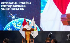
Jakarta, 7 November 2026 — Geospatial technology is playing an increasingly strategic role in strengthening national energy resilience, guiding the energy transition and maintaining ecosystem balance. Environment Minister and Head of the Environmental Control Agency (KLH/BPLH) Moh. Jumhur Hidayat made the remarks when officially opening the Pertamina Geospatial Summit 2026, themed “Geospatial Synergy for Sustainable Value Creation”, in Jakarta on Thursday (5 November 2026).
“I think this is a very proactive initiative in responding to the importance of environmental factors in every decision, whether business or investment decisions,” Minister Jumhur told participants at the forum.
According to Jumhur, geospatial technology has evolved considerably. Geospatial information is no longer merely a tool for mapping infrastructure and business activities; it has become a crucial element linked to ecosystem conditions, disaster risk mitigation, climate change adaptation and the protection of communities’ living spaces.
The energy and environment sectors are closely interconnected. Vital facilities such as power plants, pipelines, refineries and energy distribution routes require space and directly affect land and water use. Conversely, environmental changes can threaten the security and continued operation of energy infrastructure assets.
A huge business opportunity in carbon capture and storage
At the event, Jumhur set out a particularly promising future economic opportunity for Pertamina: developing a carbon capture and storage (CCS) business based on Indonesia’s wealth of geological and geospatial data.
Indonesia is considered to have a comparative advantage because of the availability of numerous underground basins with significant potential to serve as secure containers for CO₂ emissions, both from domestic and overseas sources.
“Looking ahead, there will be a business heavily based on geospatial data—specifically, geological information from our regions that can be used as containers for CCS. I think Pertamina has already begun exploring this. These are huge businesses, so Pertamina’s largest source of revenue may eventually come from them,” Jumhur said.
The economic value of carbon injection projects in geological basins is also very high. Jumhur said the potential return from CCS could reach around US$400 per tonne of CO₂ equivalent, far exceeding the conventional carbon market, where prices generally range from US$40 to US$80 per tonne. Although the projects require substantial initial investment, Indonesia’s geographical position gives it a significant competitive advantage in the sector.
Integrating climate adaptation and strengthening One Map
To anticipate the effects of weather anomalies and climate change on the energy sector, Jumhur stressed the need to integrate climate adaptation into investment planning and the long-term management of assets. The government has identified energy resilience as one of five national adaptation priorities in Indonesia’s National Adaptation Plan 2026–2030, extending towards 2035.
As a practical measure to strengthen cross-sector spatial governance, the Ministry of Environment is continuing to make greater use of thematic environmental geospatial information, as set out in Environment Minister Regulation No. 18 of 2025, in support of the national One Map policy.
Through strategic collaboration between environmental data management and the energy sector, the government hopes state-owned enterprises such as Pertamina will remain at the forefront of sustainable, environmentally friendly and economically valuable business innovation for Indonesia’s future.
Source: jawawa.id (https://jawawa.id/newsitem/environment-minister-geospatial-data-is-more-than-a-map-it-is-key-to-future-energy-investment-1794077420)
Originally published by kemenlh.go.id (https://kemenlh.go.id/news/detail/menteri-lh-data-geospasial-bukan-sekadar-peta-tetapi-kunci-investasi-energi-masa-depan), translated from Indonesian