
El Niño Arrives Sooner Than Expected, BMKG Chief Explains Why
The Meteorology, Climatology and Geophysics Agency (BMKG) has revealed that the El Niño phenomenon is now arriving more quickly compared to the previously understood pattern of occurring roughly every four years. This acceleration is attributed to global climate anomalies caused by climate change.
BMKG Chief Teuku Faisal Fathani stated that Indonesia experienced a strong El Niño in 2015, followed by occurrences in 2019, 2023, and now again in 2026. “We can see that El Niño occurred very strongly in 2015, then in 2019, again in 2023, and now in 2026. So there is an understanding that El Niño occurs every four years in Indonesia,” Faisal said during a National Dialogue event hosted by the Ministry of National Development Planning (Bappenas) in Jakarta on Tuesday. “Now it is happening every three years. This is due to global climate anomalies and climate change making it arrive faster,” he added.
Despite the accelerated frequency, Faisal emphasised that this does not mean the phenomenon will permanently shift to a two-year cycle. He noted that the emergence of El Niño cannot be mathematically predicted with certainty because it is influenced by continuously changing global climate dynamics. “It is not that mathematically precise, but we know that climate change is real. Since the pre-industrial era, the world’s average temperature has increased by 1.4 degrees Celsius, and in Indonesia, it has risen by 0.8 degrees since the 1980s. El Niño and La Niña are anomalies in sea surface temperatures in that region,” he explained.
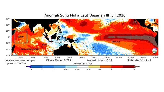
BMKG records show that this year’s El Niño conditions have also developed faster than initial forecasts. When the agency released its prediction in March 2026, the phenomenon was only expected to be in the moderate category. However, the World Meteorological Organization (WMO) confirmed in early June 2026 that El Niño was active, and BMKG’s analysis for the May-June-July period now indicates its intensity has entered the strong category.
“Based on BMKG monitoring, the current El Niño condition is in the strong category. Using the May-June-July period data, the anomaly shows an intensity of plus 1.59, placing it in a strong position with the potential to become very strong,” Faisal said. He explained that El Niño is a global climate phenomenon characterised by warming sea surface temperatures in the central to eastern equatorial Pacific Ocean. When it coincides with the dry season, it causes reduced rainfall, making the dry season drier and longer.
BMKG predicts the impact of El Niño will be most pronounced from August to September, when rainfall across most of Indonesia is expected to be in the low to very low category. The most affected areas are south of the equator, including East Nusa Tenggara (NTT), West Nusa Tenggara (NTB), Bali, Java—especially coastal areas—southern Sumatra, and South Papua.
In response to these conditions, BMKG confirmed that the government has been taking anticipatory measures for several months, including coordinating with ministries and agencies to address potential droughts, food sector disruptions, clean water supply issues, and forest and land fires. “Preparations did not just start last week with the meeting led by President Prabowo Subianto; that was a continuation of coordination that has been ongoing for months,” Faisal concluded.