
El Niño Alert: Pacific Sea Temperatures Could Hit 77-Year High, Surpassing 2016 Record
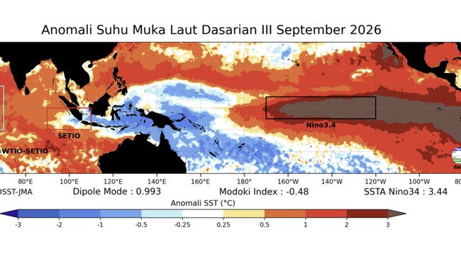
Jakarta, CNBC Indonesia — Sea-surface temperatures in the central and eastern tropical Pacific are forecast to surge to record highs during October, November and December 2026. The concerning conditions reflect the strengthening El Niño phenomenon, which is expected to dramatically alter weather patterns and have major impacts on economies, ecosystems and communities around the world.
The United Nations’ World Meteorological Organization (WMO) said its latest monthly Global Seasonal Climate Update indicates that El Niño will continue to intensify before reaching its projected peak in December. The natural phenomenon is likely to bring above-average temperatures to much of the globe and shift rainfall patterns, increasing the risk of severe droughts and floods in various regions.
The update provides authoritative information on large-scale climate drivers, including the El Niño–Southern Oscillation (ENSO), the Indian Ocean Dipole (IOD) and tropical Atlantic sea-surface temperatures, all of which affect seasonal temperatures and rainfall. It complements the WMO’s quarterly El Niño/La Niña update.
WMO Secretary-General Celeste Saulo said the current El Niño had formed with great strength and was intensifying rapidly.
“WMO forecasts indicate an almost 100 per cent probability that this event will persist until February 2027, potentially making it one of the strongest since at least 1950,” she said, as quoted on Saturday (10 October 2026).
The near-certain forecast is not based on a single model. The WMO said it represents a strong consensus among 13 national and international monitoring centres, from Washington to Tokyo, London and Pune. The assessment draws on the exchange of real-time data from ocean buoys, satellites and radiosondes coordinated by the WMO.
Speaking at the Global Heat Forum in Bangkok, Saulo offered a more detailed explanation of the ocean-warming phenomenon.
“El Niño does not add new heat to the planet. It releases heat stored beneath the ocean’s surface, which is why strong events so often coincide with one of the hottest years ever measured, as happened in 2024,” she said.
“The oceans from which that heat is drawn are the warmest we have ever measured. Put simply, there is more heat available to be released.”
Sea-surface temperature anomalies across the central-eastern equatorial Pacific, the heart of the El Niño region, are measured using the widely used Niño 3.4 index. The index rose sharply from an average of 1.6°C above normal in June 2026 to 2.5°C above normal in August.
For October to December, the seasonal average Niño 3.4 sea-surface temperature anomaly is projected to soar to around 3.7°C, peaking around December.
That would be the highest level since observations began, far exceeding the previous record of 2.6°C set between November 2015 and January 2016.
Other ocean basins are also contributing to the seasonal climate outlook. The positive IOD in the Indian Ocean—a climate pattern that can strongly affect rainfall around the ocean—is expected to peak in October before gradually weakening. Its seasonal anomaly for October to December is projected to be around 0.5°C.
Meanwhile, according to the Global Seasonal Climate Update, sea-surface temperatures in the equatorial Atlantic basin are also expected to remain above normal.
Source: jawawa.id (https://jawawa.id/newsitem/el-nino-alert-pacific-sea-temperatures-could-hit-77-year-high-surpassing-2016-record-1791647443)
Originally published by CNBC Indonesia (https://www.cnbcindonesia.com/news/20261010200202-4-774972/siaga-1-el-nino-terkuat-77-tahun-laut-mendidih-suhu-pecah-level-2016), translated from Indonesian