
Earthquake Followed by Three "Explosions", Eyewitnesses Saw Tsunami Sweep the Beach
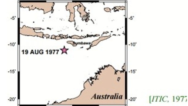
Long before the M7.7 earthquake shook East Nusa Tenggara (NTT) on Saturday (15/8/2026), the same region had experienced a catastrophic disaster. One of them occurred on 19 August 1977, exactly 49 years ago today.
That day, residents in several parts of Nusa Tenggara felt a strong earthquake. The shaking occurred twice in quick succession, with the largest earthquake occurring at around 13.00 local time. The tremors were felt as far as Sumbawa, Lombok, Sumba and Bali.
Shortly after the earthquake, residents in several villages heard three loud bangs. The sounds were heard over a range of a few seconds to more than a minute.
According to testimony collected by the International Tsunami Information Center (ITIC), the sound was like a ‘bomb explosion’ or ‘sonic boom’. Residents said the sound seemed to come from the direction of the sea, as if it were a sign that something was about to happen.
That sign turned out to be correct. The sea water suddenly receded, leaving the beach area dry for about 100-200 metres. For residents who did not know the signs of a tsunami, the phenomenon was certainly confusing.
A few moments later, a large wave came crashing onto the coast. Citing the research The Tsunami Run-up Assessment of 1977 Sumba Earthquake in Kuta, Center of Lombok, Indonesia (2015), four witnesses admitted to being directly hit by the tsunami. Some were swept away while running towards high ground, some returned home to save their children, some remained in their homes, and some survived after climbing trees.
So, what actually happened in East Nusa Tenggara that day?
Shigehisa Nakamura in A Note on the Indonesian Earthquake and Tsunami of 19 August 1977 (1979) recorded that two earthquakes occurred in quick succession that day. The first earthquake had a magnitude of M6.2, followed by the main earthquake at around 13.00 local time.
Based on a report from the Institute of Meteorology and Geophysics (IMG) cited by Nakamura, the main earthquake had a magnitude of around M8. Its epicentre was located at around 118.6°E and 11.8°S, with a depth of 33 kilometres.
However, several reports recorded different magnitudes. An initial report from the Pacific Tsunami Warning Center (PTWC) stated M7.7. Meanwhile, research by Eko Pradjoko et al. in The Tsunami Run-up Assessment of 1977 Sumba Earthquake in Kuta, Center of Lombok, Indonesia (2015) recorded a magnitude of M8.3.
The earthquake then triggered a large tsunami that struck the coast of Nusa Tenggara.
According to the National Centers for Environmental Information website, the tsunami reached a height of more than 10 metres along the coast of Sumbawa. In areas that were difficult to reach, the tsunami reached at least 15 metres above the highest tide level.
The impact was enormous. Sumbawa and Lombok were the areas with the most severe damage. Based on data cited by Nakamura, more than 180 people died and around 3,900 people lost their homes.
In addition to Indonesia, the tsunami even reached Australia. In Dampier, the tsunami height reached 2 metres, while in Port Sampson it ranged from 2-4 metres and in Cape Leveque it reached 6 metres.
However, the 1977 Sumba earthquake and tsunami was not the last. History again records that the East Nusa Tenggara region is frequently hit by earthquakes, one of the most severe occurring in 1992 when Flores, NTT, was struck by an M7.5 earthquake and a tsunami of around 20 metres.