
Difficult Terrain Hampers Efforts as Bromo Fire Scorches 60 Hectares of Conservation Land
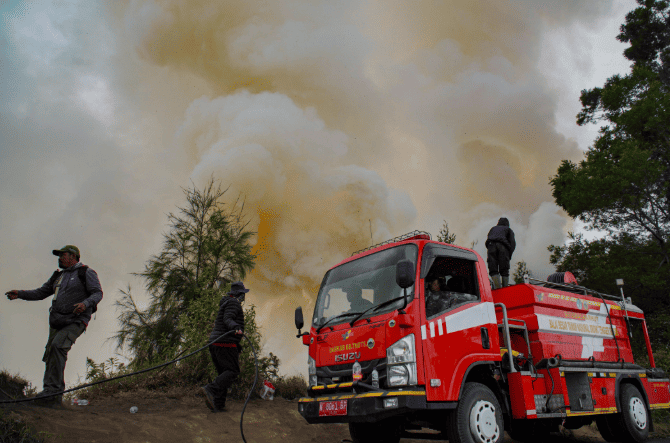
The wildfire in the Mount Bromo conservation area, East Java, continues to spread. The National Disaster Management Agency (BNPB) reported that the total area of land scorched by the fire had reached approximately 60 hectares as of Thursday morning (6/8).
Head of the BNPB Data, Information and Disaster Communication Centre, Abdul Muhari, detailed that the affected area spans two administrative regions, namely Probolinggo Regency and Malang Regency. “In Probolinggo Regency, the fire has burned around 10 hectares of land in the Watu Gede area, Sariwani Village, Sukapura District. Meanwhile, in Malang Regency, the fire has burned 50 hectares of the Jantur area within the Bromo Tengger Semeru National Park (TNBTS),” Abdul Muhari explained in a written statement in Jakarta on Thursday (6/8).
The accumulated figure for the land area was obtained based on provisional calculation data from the joint task force team as of Wednesday afternoon (5/8). Abdul Muhari added that the hotspot was first detected consuming the conservation area on Monday evening (3/8). Although the flames have burned tens of hectares of land, there have been no reports of casualties in this incident.
Emergency response efforts are being intensified by a joint team consisting of the Regional Disaster Management Agency (BPBD), the TNBTS Centre, Forest Police (Polhut), fire engines, water tanker trucks, and volunteers. Several hotspots, such as in the Bantengan Block and Pusung Jantur, were reported to have been temporarily extinguished. However, strong winds and the extremely steep geographical terrain of the Bromo caldera slopes caused the fire to flare up again, complicating ground firefighting operations.
To maximise firefighting operations in extreme areas that are difficult for personnel to reach, the East Java BPBD has deployed monitoring drones. “East Java BPBD personnel deployed drones to map the distribution of hotspots located in hard-to-reach areas, from around the caldera to the border monument between Malang Regency and Lumajang Regency,” explained Abdul Muhari.
Source: jawawa.id (https://jawawa.id/newsitem/difficult-terrain-hampers-efforts-as-bromo-fire-scorches-60-hectares-of-conservation-land-1785984625)
Originally published by Media Indonesia (https://mediaindonesia.com/nusantara/918847/terkendala-medan-terjal-kebakaran-bromo-hanguskan-60-hektare-lahan-konservasi), translated from Indonesian