Dangers on Java's North Coast: Warning Signs of a Critical Situation
Tubagus Solihuddin, a researcher at the Centre for Atmospheric Research of the National Research and Innovation Agency (BRIN), has revealed high levels of abrasion in the coastal areas of Java’s North Coast. The total reaches 65.8% across the region stretching from Serang to Situbondo.
These findings on changes come from Sentinel satellite imagery over the period from 2000 to 2024. In addition to the erosion rate of 65.8%, land addition or accretion levels were found to be only 34.2%.
He explained that high demographic pressures have led to the development of settlements and economic activity centres along the North Coast. This has ultimately resulted in uncontrolled extraction of marine and coastal resources.
“So, 84% of Java’s North Coast consists of fluvial deposits and delta deposits. Geologically, the deposits forming Java’s North Coast are still unconsolidated. They are not yet strongly compacted, making them highly susceptible to erosion and compaction,” Tubagus explained, quoted from BRIN’s official website on Tuesday (5/4/2026).
This condition is further worsened by the morphological state along the North Coast. It is dominated by low-lying coastal plains with elevations below 10 metres.
Tubagus also highlighted massive erosion anomalies occurring in delta environments, which are naturally areas of sedimentation. This situation is linked to modification activities in the upstream areas, such as canalisation, river diversions, and dam construction.
Anthropogenic modifications are evident at several points. For example, a 1.72 square kilometre area of land in Tanjung Pontang, Serang, has vanished due to erosion from the diversion of the Ciujung Baru River flow.
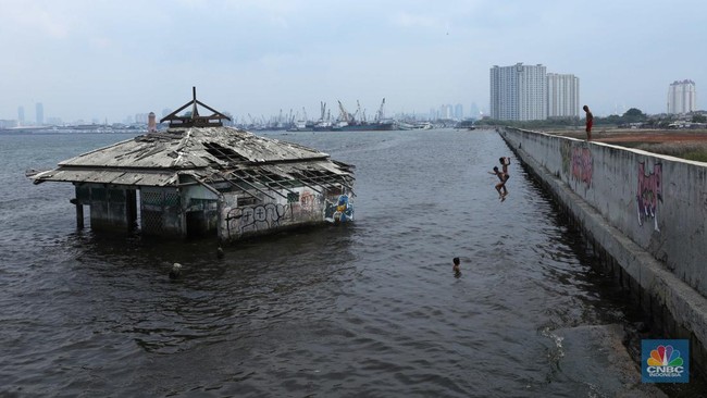
Meanwhile, seawater has penetrated up to 4 km inland in Pantai Bahagia, Muara Gembong, Bekasi. This has permanently submerged public infrastructure and inundated over 1,000 hectares of community-owned shrimp ponds.
Another finding is the condition of land subsidence. Tubagus explained that the highest rate of land subsidence is in Demak at 16 cm per year, followed by Jakarta (15 cm/year), Sidoarjo (14 cm/year), Pekalongan (11 cm/year), Surabaya (8 cm/year), Brebes (7 cm/year), and Serang, Cirebon, and Indramayu (6 cm/year each).
He described this problem as systemic. Triggers include massive land use conversion, encompassing 1,500 square km of built-up areas and 5,449 square km of rice fields, as well as mangrove clearance and sporadically constructed, non-integrated wave barriers.
Tubagus stated that it is important to transition to a cross-sectoral and regional approach. According to him, there is no single solution that can be applied across the entire area, as each coast has different characteristics and morphology.
Policy directions are also requested to be based on credible scientific research. Additionally, they should prioritise ecosystem balance, rather than merely infrastructure development.