
Burned Land Area in West Kalimantan Reaches 48,536 Hectares, with 19 Hotspots Remaining
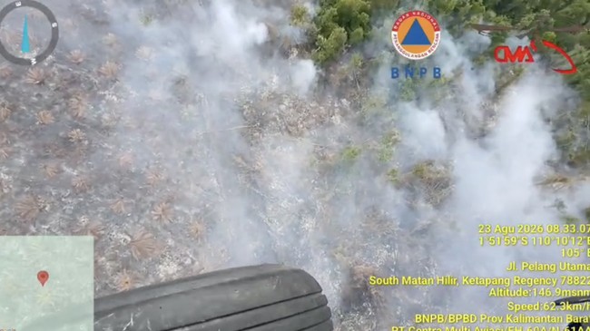
Forest and land fires (karhutla) remain a government concern in several regions of Indonesia. One of the worst-affected areas is West Kalimantan, where the total burned land has reached 48,536 hectares as of 14 September 2026.
Acting Head of BNPB’s Disaster Data, Information and Communication Centre, Berton Panjaitan, said the figure combines SiPongi data up to 31 July 2026 of 38,310 hectares with BNPB field measurements taken between 1 August and 14 September 2026 of 10,224 hectares.
“We combined the SiPongi figures with the data from our own measurements to arrive at the current total burned area. We can confirm that in West Kalimantan, the burned land from SiPongi is more than 38,310 hectares, while our field measurements show more than 10,224 hectares, bringing the total to 48,536 hectares,” Berton said at a BNPB press conference on Tuesday (15/9/2026).
According to BNPB data as of 14 September 2026, 19 fire spots (FS) remain, with an estimated burned area of 261.5 hectares.
Of that area, 180.8 hectares have been successfully extinguished. The breakdown shows the Ground Task Force put out 175.8 hectares, whilst the Air Task Force extinguished 5 hectares through water bombing. This leaves roughly 80.7 hectares still to be handled on Tuesday (15/9/2026).
The firefighting operation in West Kalimantan involves substantial resources. BNPB has deployed 14,759 Ground Task Force personnel, five units for weather modification operations (OMC) and patrols, and nine helicopters for water bombing. However, aerial firefighting efforts have been hampered by poor visibility.
Berton said a CH-47 Chinook helicopter provided by Japan has arrived in West Kalimantan, but the aircraft cannot yet be used for firefighting operations because visibility remains too low.
“We can confirm that the Japanese helicopter assistance has now arrived in West Kalimantan, but it cannot yet be operated because visibility is very low. The Japanese side wants to conduct operations when visibility reaches 3,500 to 5,000 metres,” he said.
The situation comes as several areas of West Kalimantan are experiencing extremely poor visibility. According to BNPB data, visibility below 1 kilometre has been recorded in Mempawah, Pontianak, Melawi, Sambas, Ketapang, Kubu Raya, Sintang, Kapuas Hulu and Singkawang city.
Meanwhile, weather in parts of West Kalimantan is beginning to show light to heavy rain, including in Sambas, Sintang, Bengkayang, Singkawang city and Sekadau.
Nevertheless, air quality remains a concern. BNPB has recorded that a number of affected areas are experiencing poor air quality due to pollutants from the fires.
Based on the BMKG’s pollutant dispersion forecast for 15-16 September 2026, the highest concentrations of pollutants remain over West Kalimantan, Central Kalimantan and South Kalimantan. Pollutant spread has also been detected in parts of South Sumatra, northern Sumatra, the Bird’s Head region of Papua and Merauke.
BNPB is reminding residents in fire-affected areas to wear masks, especially when carrying out outdoor activities.
Beyond West Kalimantan, fires are still burning in several other priority provinces. As of 14 September 2026, the total burned land is recorded at around 19,303.99 hectares in South Kalimantan, 19,851.65 hectares in Riau, 15,976.1 hectares in Central Kalimantan, 6,552.31 hectares in South Sumatra, 5,761.57 hectares in East Kalimantan and 2,998.02 hectares in Jambi.
Berton said the response is being carried out in a large-scale, measured manner, prioritising the Ground Task Force supported by the Air Task Force.
“Extinguishing operations are being conducted on a massive and measured scale in the field. We are prioritising the Ground Task Force, effectively supported by the Air Task Force, for maximum results,” Berton said.
For East Kalimantan, BNPB records 319.95 hectares still requiring attention, particularly around the Nusantara Capital City (IKN) area. In Central Kalimantan, around 113.7 hectares remain, South Kalimantan 73.98 hectares, South Sumatra 84.25 hectares, Jambi 10 hectares and Riau 21.8 hectares from the latest fires still needing to be handled.
The government is also reinforcing personnel and equipment in the field, including accelerating the mobilisation of firefighting equipment and strengthening the integration of fire data.
“The success of this operation is supported by enhanced synergy and genuine cooperation from all elements, including central and regional government, such as BNPB, BPBD, the fire brigade, Satpol PP, other regional apparatus organisations, the TNI, Polri, Manggala Agni, Fire Care Communities or volunteers, the private sector and companies, and other elements of society,” he said.
The government is also urging the public to refrain from activities that could spark fires, such as burning rubbish carelessly or discarding cigarette butts before ensuring they are fully extinguished. Residents can report fire spots through the BNPB call centre on 117, BPBD or relevant agencies.
Source: jawawa.id (https://jawawa.id/newsitem/burned-land-area-in-west-kalimantan-reaches-48-536-hectares-with-19-hotspots-remaining-1789480352)
Originally published by CNBC Indonesia (https://www.cnbcindonesia.com/news/20260915170901-4-768159/luas-lahan-terbakar-di-kalbar-tembus-48536-ha-masih-ada-19-hotspot), translated from Indonesian