
BRIN's Forest Fire Suppression Technology vs the World
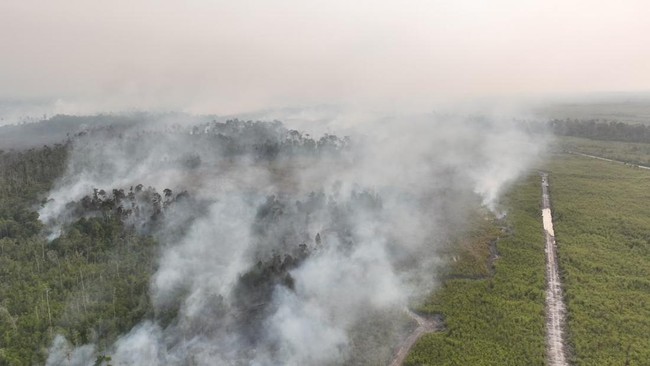
Forest and land fires (karhutla) have once again become a concern in Indonesia during the 2026 dry season, particularly in several regions of Kalimantan and Sumatra.
The ongoing dry conditions make prevention and early detection increasingly important before hotspots develop into large-scale fires.
The National Research and Innovation Agency (BRIN) assesses that handling forest and land fires requires the integration of various data and technologies because it is influenced by many variables, ranging from weather conditions and vegetation to land characteristics.
To support its handling, the agency has developed a number of technologies supported by artificial intelligence (AI), ranging from satellite-based detection systems to weather modification technology.
BRIN’s role primarily lies in research, technology development, and the provision of information that is then used by operational agencies such as the Ministry of Forestry and disaster management institutions.
One of its developments is the Geoinformatika Multi Input Multi Output (GEOMIMO) platform.
This system is designed to integrate various remote sensing data and algorithms so that forest and land fire information can be used from the pre-disaster to post-disaster stages. The technology also utilises AI and satellite imagery to support hotspot detection.
There are three main technologies that stand out from the explanation given by BRIN Head Arif Satria in August 2026.
First, GEOMIMO, which is based on satellites and AI.
This system integrates satellite imagery with artificial intelligence to help detect hotspots. BRIN states that the AI-based platform has been developed for some time and has been adopted by the Ministry of Forestry.
Second, Dumakron for weather modification.
BRIN has developed a seeding material in the form of hygroscopic salt or NaCl measuring around 2-5 microns. Its very small size allows dispersal using unmanned aircraft or drones, with the aim of increasing the efficiency of the weather modification process.
Third, flare technology.
BRIN has developed flare technology to support weather modification operations. Flares are used to release salt particles into clouds to help the process of rain formation. This technology is one alternative dispersal method in weather modification operations and can be used according to cloud conditions and needs in the field.
At the global level, fire suppression technology is increasingly developing towards near real-time detection, continuous monitoring, AI, and prediction of fire movement.
In the United States, fire suppression technology is beginning to combine AI, sensors, cameras, satellites, and drones to accelerate detection and initial response. The latest developments are even moving towards AI-based firefighting drones.
In the XPRIZE Wildfire competition in Alaska, one system was reported to be able to detect and extinguish a controlled fire in less than 12 minutes without human involvement, showing the direction of technology towards automated response in the first minutes of a fire.
Australia is also developing an AI-based approach through the Bushfire Emerging Technologies Hub established by the Australian and New Zealand Council for fire and emergency services (AFAC).
The technologies being tested include AI for determining response priorities, systems on fire trucks that can recognise fire boundaries in real time, as well as drones and aerial infrared technology to detect still-smouldering fires.
Canada, meanwhile, is developing WildFireSat, a dedicated satellite for monitoring fires that is targeted for launch in 2029. The system is designed to combine fire information with wind data, vegetation, landforms, and drought levels to help predict fire behaviour and determine which fires need to be prioritised.
Conceptually, BRIN’s technology is already moving in the same direction as global systems, particularly through the use of satellite imagery, AI, drones, and data integration. GEOMIMO has functions in line with systems such as FIRMS and Digital Earth Australia in making remote sensing data the basis for detection and decision-making.
The difference is that a number of global technologies are beginning to move beyond merely detecting hotspot locations towards monitoring, prediction, and initial response in real time. In certain systems, human involvement can even be minimised so that the process from detection to response takes place within minutes. This is important because in forest fires, the speed of response greatly determines whether a hotspot can be controlled or develops into a major fire.
On the other hand, BRIN has a distinctive approach through weather modification.
Dumakron and flare give Indonesia instruments to intervene in atmospheric conditions when suitable clouds are available. This means that BRIN’s technology does not only operate in detection, but also in efforts to mitigate dry conditions that can increase the risk of forest and land fires.
Source: jawawa.id (https://jawawa.id/newsitem/brins-forest-fire-suppression-technology-vs-the-world-1787633467)
Originally published by CNBC Indonesia (https://www.cnbcindonesia.com/research/20260824190503-128-762059/adu-canggih-teknologi-pemadam-karhutla-brin-vs-dunia), translated from Indonesian