BRIN Reveals Giant Hole in Central Aceh Is Not a Sinkhole, Explains True Cause
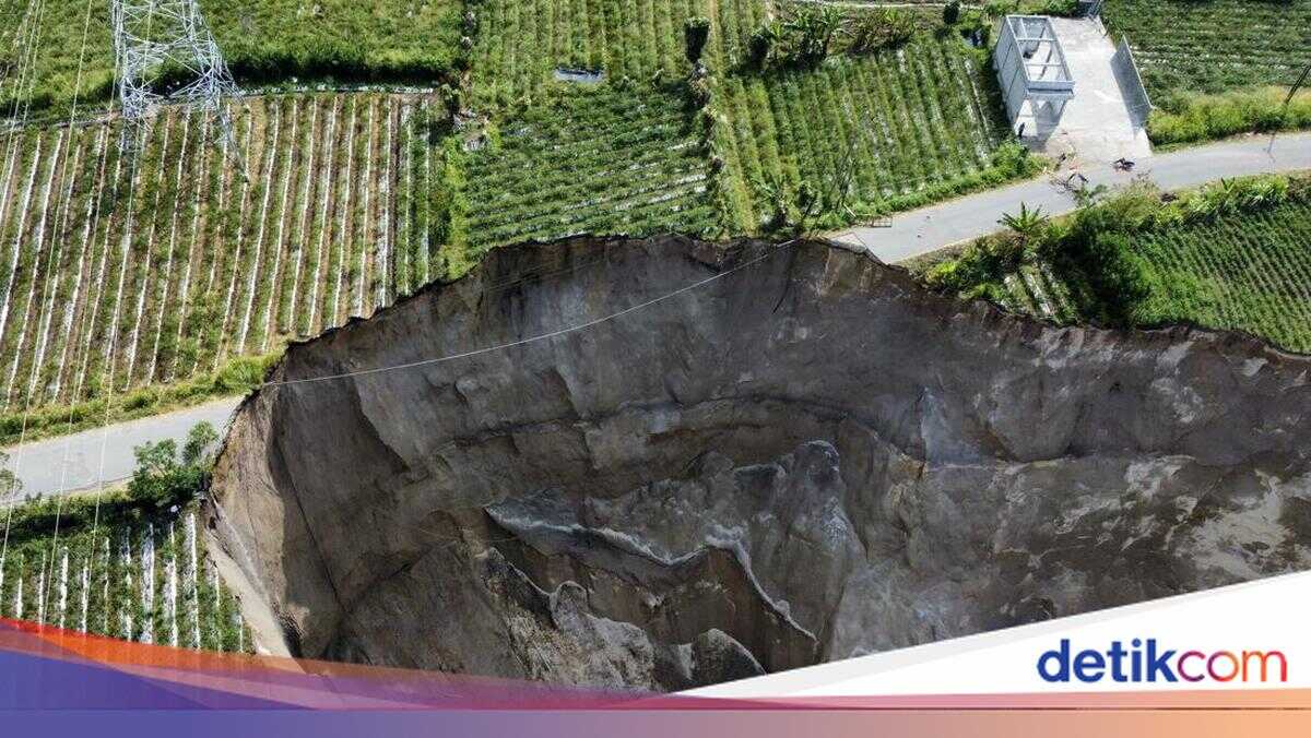
The Head of the Geological Disaster Research Centre at the National Research and Innovation Agency (BRIN), Adrin Tohari, has revealed that the giant hole in Pondok Balik Village, Ketol District, Central Aceh, is not a sinkhole phenomenon. Adrin stated that the hole was caused by geological landslides.
Adrin explained that the area does not consist of limestone, which typically triggers sinkholes. Rather, it is composed of tuff material resulting from the activity of the now-inactive Mount Geurendong. This tuff, Adrin continued, is a young geological layer that has not been properly compacted, making it prone to collapse.
“What occurred in Central Aceh is actually a landslide phenomenon, not a sinkhole. The tuff layer is not dense and has low strength, making it very easily eroded and prone to collapse,” Adrin explained in a statement on Saturday (21/2/2026).
Adrin elaborated that based on Google Earth satellite imagery dating back to 2010, the area had already shown signs of a small valley that progressively widened over time due to erosion and landslide processes. He said the process has continued, causing the valley to increasingly widen and elongate until it formed a large hole.
Adrin noted that earthquake activity is also suspected of accelerating the landslides. The magnitude 6.2 earthquake that struck Central Aceh in 2013 is estimated to have weakened slope structures and triggered increasing instability.
In addition to earthquakes, he said heavy rainfall has also been a primary trigger. The fragile tuff rock easily becomes saturated with water, causing the soil layers to lose their cohesion and ultimately collapse.
Adrin added that open plantation irrigation channels have also accelerated the landslide process. Water seeping into the ground increases the moisture content of the tuff layers, making them more susceptible to collapse.
“If irrigation channels are open and water continues to enter the ground, then the already fragile layers become even more unstable,” he said.
Adrin disclosed a hypothesis regarding groundwater flow eroding the boundary between the fragile tuff layer and the denser rock beneath it. This, he said, causes the upper portion of the cliff to lose its support and collapse gradually.
According to him, this phenomenon did not occur suddenly but is a process that has been unfolding over decades to hundreds of years.
He said similar conditions can be found in other regions with young volcanic rock geological characteristics. He cited the Sianok Canyon in West Sumatra as an example, which was formed through a lengthy geological process related to the tectonic activity of the Great Sumatran Fault with similar rock characteristics.
His agency, he said, has not yet conducted direct field research to further confirm the cause of the phenomenon. However, BRIN has carried out analysis based on satellite imagery and public data.
“We have only analysed based on imagery data and public information so far. To determine the cause in detail, comprehensive research is required,” he explained.
Furthermore, Adrin proposed that ground movement vulnerability maps be updated following this event. He also reminded the public to remain vigilant for early warning signs such as the appearance of ground cracks or minor subsidence in the surrounding area.
“Ground movement vulnerability maps already exist, but they need to be updated after this event to be more accurate and operational. The most important thing now is to understand the process and immediately take mitigation steps so that the risk of casualties can be avoided,” he concluded.