
BNPB Maps Impact of M7.7 NTT Earthquake from the Air, Prepares Logistics Drops
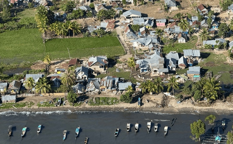
The National Disaster Management Agency (BNPB) has carried out an aerial survey to map the condition of areas affected by the magnitude 7.7 earthquake in Nusa Tenggara Timur (NTT). The move also aims to identify routes and distribution points for logistical aid to areas that are difficult to reach by land.
The survey, conducted on the seventh day after the earthquake on Wednesday (26/8), covered areas from Labuan Bajo in West Manggarai to Nagekeo Regency. The monitoring was led directly by BNPB Deputy for Prevention Abdul Muhari, using a helicopter flying at an altitude of around 25-30 metres above ground level.
Based on visual observations, BNPB found a number of settlements in hilly areas that are isolated because access roads cannot be traversed by four-wheeled vehicles. The extreme topographical conditions make it impossible to deliver aid using logistics trucks.
“Conditions like this are certainly quite difficult if pursued with logistics trucks or transport vehicles carrying up to 1 tonne of aid. So for these areas we will optimise logistics drops by air,” said Abdul Muhari.
In addition to mapping building damage, the team also documented a complete series of aerial photographs to see the impact of the disaster from coastal areas to inland areas in order to validate reports from local district governments.
Regarding the tsunami potential that triggered an early warning from BMKG shortly after the earthquake on Saturday (15/8), BNPB stated that the impact was generally minor. Nevertheless, aerial monitoring remained focused on areas with basin and bay topographical characteristics that could amplify waves.
Abdul Muhari explained that the tsunami impact in the form of inundation was only found at two points, namely in Riung and on the border between Riung and Nagekeo. However, because the area is dominated by fish ponds, the impact on residential areas was assessed as insignificant.
As a follow-up, BNPB will integrate the results of this aerial survey with ground surveys to obtain a more detailed picture of damage to residents’ homes. Air operations will continue to be optimised to ensure humanitarian aid reaches residents in remote locations.
Source: jawawa.id (https://jawawa.id/newsitem/bnpb-maps-impact-of-m7-7-ntt-earthquake-from-the-air-prepares-logistics-drops-1787730659)
Originally published by Media Indonesia (https://mediaindonesia.com/nusantara/926073/bnpb-petakan-dampak-gempa-m77-ntt-dari-udara-siapkan-dropping-logistik), translated from Indonesian