BMKG Explains Rainfall in Indonesia Despite El Niño Dry Season
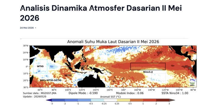
Jakarta, CNBC Indonesia - The Meteorology, Climatology, and Geophysics Agency (BMKG) has reported that Indonesia is currently experiencing the El Niño phenomenon, marked by a 10-day ENSO index of +1.00 (+0.52).
Simultaneously, BMKG noted that 20.1% of Indonesia’s territory (141 ZOM) is experiencing the dry season, based on ZOM counts.
The dry season is affecting parts of Aceh, North Sumatra, Riau, the Riau Islands, northern Banten, parts of Jakarta, northern West Java, central Java, eastern Java, Bali, most of West Nusa Tenggara (NTB), most of East Nusa Tenggara (NTT), Gorontalo, Central Sulawesi, small parts of West Sulawesi, South Sulawesi, Southeast Sulawesi, Maluku, and southern Papua.
So why is Jakarta still experiencing rainfall? Heavy downpours have been reported in several regions, even triggering flood disasters.
The National Disaster Management Agency (BNPB) reported flooding in Waru Jaya Village, Parung District, and Cijayanti Village, Babakan Madang District, on Sunday (24 May 2026). Flooding was also reported in Bahoruru Village, Bungku Tengah District, Morowali Regency, on the same day.
According to BMKG, El Niño is a phenomenon of warming waters in South America. This condition is linked to widespread ocean warming anomalies in the eastern Pacific Ocean, extending as far as the International Date Line in the central Pacific.
Like La Niña, El Niño has varied impacts across Indonesia, particularly on monthly and seasonal rainfall patterns.
El Niño occurring during June-July-August (JJA) and September-October-November (SON) typically causes reduced rainfall across most of Indonesia.
When occurring in December-January-February (DJF), El Niño generally leads to decreased rainfall in central and eastern Indonesia.
However, during March-April-May (MAM), El Niño’s impact on rainfall varies across different regions.
“El Niño does reduce rainfall in Indonesian regions, particularly during the JJA and SON seasons by over 40%. However, some areas experience increased rainfall during DJF and MAM even during El Niño,” BMKG stated on Monday (25 May 2026).
“Thus, it cannot be concluded that there will be no rainfall during El Niño. However, rainfall is reduced by over 40%,” BMKG added.
In the 2nd 10-day Atmospheric Dynamics Analysis released by BMKG on 24 May 2026, a High Rainfall Early Warning for the 3rd 10-day period of May 2026 was issued.
Warnings are classified as ‘Waspada’ (Caution) for several regencies in Central Java, South Kalimantan, East Kalimantan, Maluku, South Papua, Central Papua, South Sulawesi, and South Sumatra. ‘Siaga’ (Alert) for some regencies in Central Java. No ‘Awas’ (Warning) classifications were issued.
No Meteorological Drought Early Warnings were issued for the May 2026 3rd 10-day period across all classifications.
“Rainfall during the third 10-day period of May and second of June 2026 is generally forecast to be in the Medium-Low category (0-150 mm per 10-day period),” BMKG stated.
Rainfall Warnings for Indonesian Regions
In its one-week rainfall potential report, BMKG warned of possible rain between 22-28 May 2026, driven by atmospheric wave activity and cyclonic circulation, which could increase rainfall chances across parts of Indonesia.
“Intraseasonal atmospheric dynamics continue to support rain cloud formation. The Madden-Julian Oscillation (MJO) is forecast to be in phase 4 (Maritime Continent), with spatial filter analysis indicating active MJO over the Riau Islands, Kalimantan, Sulawesi, Maluku, southern North Maluku, and northern Papua. These conditions could enhance convective cloud formation across several Indonesian regions despite El Niño’s ongoing influence,” BMKG stated.
Additionally, Indonesia’s weather in the coming week is expected to be influenced by several atmospheric wave activities. Eastward-propagating Kelvin waves are predicted to be active over the Andaman Sea, Aceh, North Sumatra, Strait of Malacca, North Natuna Sea, and North Kalimantan.
“Meanwhile, Equatorial Rossby waves propagating westward are forecast to be active in central to southern Kalimantan, central to southern Sulawesi, NTB, NTT, Maluku, southern West Papua, and western Central Papua,” BMKG added.
“Mixed Rossby-Gravity (MRG) waves are forecast to be active in Aceh, North Sumatra, the Riau Islands, Makassar Strait, West Sulawesi, Central Sulawesi, and South Sulawesi over the next week. These atmospheric wave activities could enhance moisture supply and support rain cloud formation in affected areas,” BMKG added.
Cyclonic circulation is also predicted to form in the western Bengkulu Indian Ocean, Makassar Strait, Maluku Sea, and northern Pacific Ocean near Papua. These systems create convergence and confluent zones from western Aceh to western West Sumatra, Flores Sea, Maluku waters, from Halmahera Sea to Philippine Sea, and around the cyclonic circulation. A combination of tropical wave activity, circulation patterns, wind shear, and high humidity supports rain cloud development in affected regions.