
BMKG Chief Issues Stark Warning Over 13 Megathrust Zones in Indonesia
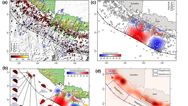
The Meteorology, Climatology, and Geophysics Agency (BMKG) has again reminded the public not to be complacent about the threat of large earthquakes that could potentially occur in Indonesia. This warning comes amid a trend of increasing seismic activity in recent years and the existence of several megathrust zones that are still accumulating energy.
BMKG Head Dwikorita Karnawati stated that Indonesia is one of the countries with the highest levels of tectonic activity in the world. Besides being located at the meeting point of three major world plates, Indonesia also has many active earthquake sources that could trigger large earthquakes and tsunamis.
Citing BMKG data, Indonesia sits at the convergence of three major world plates: the Indo-Australian, Pacific, and Eurasian plates. This condition means the country has more than a dozen megathrust segments and hundreds of active faults that act as earthquake sources.
“The incidence of earthquakes in Indonesia has seen a significant jump in recent years, indicating an increase in seismic activity that we need to be wary of,” Dwikorita stressed.
According to Dwikorita, BMKG data shows the average number of earthquake events was around 2,254 per year in the 1990-2008 period. This figure rose to approximately 5,389 per year in the 2009-2017 period. Entering 2018 and 2019, the number surged to over 11,000 events per year. In 2024, BMKG recorded 29,869 earthquake events, while the number of monitoring sensors was not significantly different from the previous year.
“The seismic activity monitored by BMKG has jumped. Based on long-term earthquake data, there is a pattern of earthquake occurrences in Indonesia continuing to increase every year,” she said.
Dwikorita emphasised that the surge in the number of earthquakes was not solely due to an increase in monitoring equipment. “Starting in 2020, the number of instruments increased to around 300, but earthquake occurrences actually decreased. This disproves the assumption that the increase was due to more instruments. Perhaps the tectonic activity decreased at that time,” she said. “Then, as we added more instruments up to 2023, the number of events did not rise significantly, although it remained above 11,000. This means the increase in recorded earthquakes is not because of the additional instruments.”
Meanwhile, Head of the BMKG Earthquake and Tsunami Centre Daryono explained that Indonesia is in a highly complex tectonic setting, resulting in numerous earthquake sources. “Indonesia is located at the meeting point of three major world plates: the Indo-Australian, Pacific, and Eurasian plates. As a result, Indonesia has 13 megathrust segments, which are earthquake sources capable of triggering large quakes,” he said.
“Not only that, there are 295 identified active fault segments. However, many more remain unidentified. This condition makes Indonesia one of the most earthquake-prone countries,” Daryono added. He explained that Indonesia receives pressure from various directions, making its seismic activity very high. “From the south, it is pressured by Australia, by the Pacific Ocean plate, the Philippine Sea plate, and also the tectonic escape aspect from Indo-China which presses on Indonesia. Because India is pressing northward, Indo-China is pressing us. So Indonesia is besieged from all directions, hence the numerous earthquake sources.”
Referring to the 2017 Indonesia Earthquake Source and Hazard Map, there are 13 megathrust segments threatening Indonesian territory. These segments include Mentawai-Pagai with a potential magnitude of 8.9, Enggano (M8.4), Sunda Strait (M8.7), West Java-Central Java (M8.7), East Java (M8.7), Sumba (M8.5), Aceh-Andaman (M9.2), Nias-Simeulue (M8.7), Batu (M7.8), Mentawai-Siberut (M8.9), North Sulawesi (M8.5), Philippines (M8.2), and Papua (M8.7).
Daryono stressed that concerns about the potential for a large earthquake are not unfounded. He noted that the situation in Japan serves as a reminder that megathrust zones which have not released energy for a long time must still be watched. “The release of an earthquake in these two megathrust segments could be said to be ‘just a matter of time’, because these two regions have not experienced a large earthquake for hundreds of years,” Daryono said. However, he confirmed that a large earthquake occurring in the Nankai Megathrust, Japan, would not trigger changes to the tectonic plate system in Indonesia due to the vast distance.
“If the concerns about an earthquake conveyed by Japanese experts become a reality, it will indeed be a devastating quake that not only causes damage but also triggers a tsunami,” Daryono said. “The question is, if that devastating earthquake occurs, will it affect the tectonic plates in Indonesia? The answer is, if a large earthquake occurs in the Nankai Megathrust, the large-scale rock deformation that occurs is confirmed not to impact the tectonic plate system in the Indonesian region, because the distance is too far, and typically the tectonic dynamics that occur are only local to regional scale on the Nankai Subduction system.”
BMKG itself continues to strengthen mitigation efforts by adding a network of seismograph sensors, developing earthquake and tsunami shaking models in various regions, and improving early warning systems and public education. “In preparation, we are conducting a shaking scenario model for the Sunda Strait megathrust earthquake. We have conveyed this to local governments and related parties so they can prepare. We have also completed this scenario with a tsunami model with heights above 3 metres, possibly reaching over 10 metres, even 20 metres in the Sunda Strait,” Dwikorita revealed. “Thus, we must continue to be vigilant of the seismic gap zones in the South of Banten and the Sunda Strait, which have existed since 1757, and in the Mentawai-Siberut region since 1797. It has been more than 227 years. We must prepare for this.”