
AISITS System Reveals Last Known Location of KM Virgo in Madura Strait
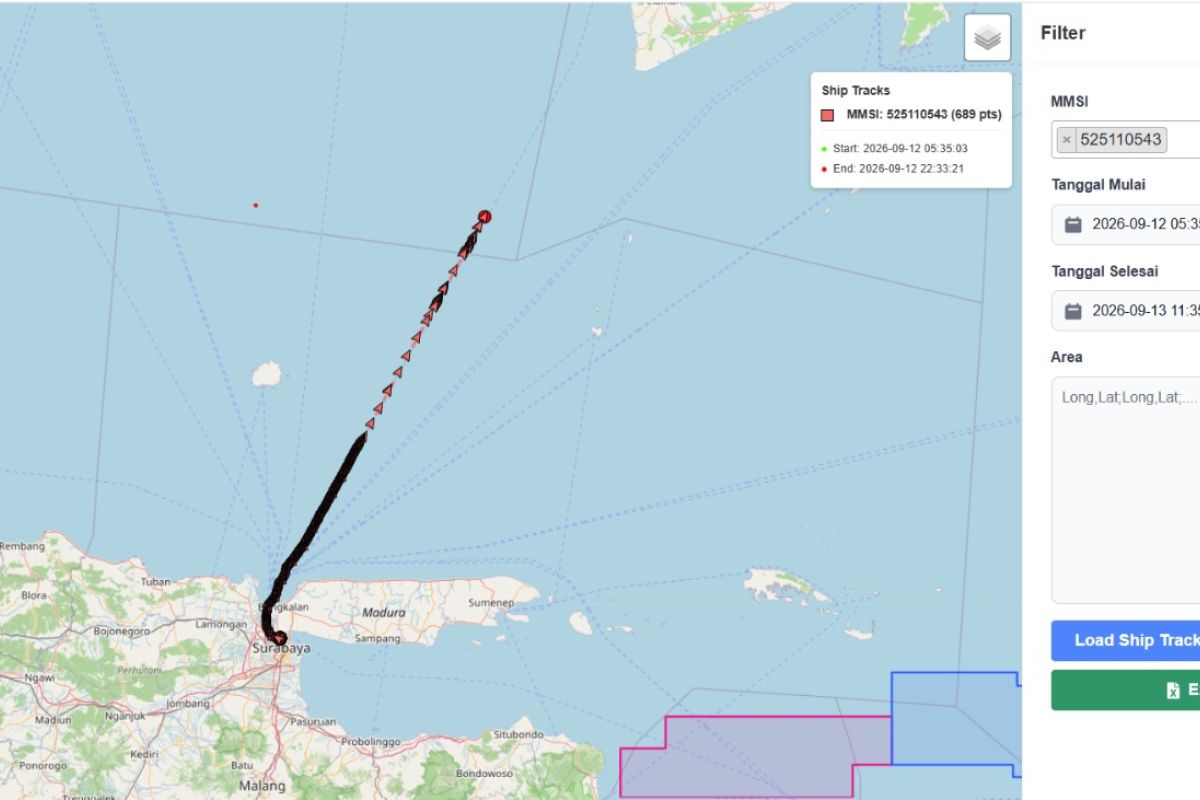
Surabaya (ANTARA) - The Automatic Identification System of ITS (AISITS) has revealed the last known tracks of KM Virgo Transport 8 in the Madura Strait before the ship’s signal ceased to be detected on Saturday (12/9).
“The journey of KM Virgo was recorded through data received by the Remote Base Station (RBS) and the AISITS server since the ship departed from the South Jamrud Terminal,” said Dr Eng Dhimas Widhi Handani ST MSc, a Shipbuilding Systems Expert from the Institut Teknologi Sepuluh Nopember (ITS) in Surabaya, on Sunday.
Based on the data, KM Virgo departed from the South Jamrud Terminal on Saturday (12/9) at approximately 10:00 WIB. The vessel moved at speeds between 0.3 and 3.5 knots within the port area before entering the Surabaya West Shipping Channel (APBS).
After entering the APBS, the ship’s speed increased to between 12 and 14 knots. While near Karang Jamuang at approximately 12:00 WIB, the ship was recorded travelling at a constant speed of 13 to 14 knots.
“Through the AISITS server, the ship’s journey then continued towards the northeast, heading for Banjarmasin, Kalimantan,” he said.
According to him, this situation may have occurred because the ship moved beyond the coverage range of the AISITS reporting system.
Furthermore, there is a possibility that the AIS transponder device on the ship stopped transmitting data, noted the ITS Shipbuilding Systems lecturer.
The Head of the ITS Reliability and Safety Laboratory stated that historical AISITS data can assist in identifying maritime incidents, including detecting vessels that deviate from their routes or stop in prohibited locations.
This data can also be utilised to monitor vessel movements around vital facilities, such as undersea pipelines and offshore platforms.
In addition to accident investigation, AISITS features several functions to support maritime security, including an early warning system, ship tracking system, fuel oil monitoring, and smart buoy monitoring.
The system is also equipped with a predictive manoeuvring plan, weather information, and ship traffic density maps or heat maps.
All early warnings can be monitored via an application or through a coastal command centre.
He noted that such monitoring allows relevant parties to quickly ascertain vessel traffic conditions, enabling the anticipation of potential disruptions to vital infrastructure.
The use of AISITS represents a technological advancement in supporting the surveillance of Indonesian waters, including real-time vessel movement monitoring and the provision of historical data for investigative purposes.
Source: jawawa.id (https://jawawa.id/newsitem/aisits-system-reveals-last-known-location-of-km-virgo-in-madura-strait-1789289931)
Originally published by Antara (Indonesian) (https://www.antaranews.com/berita/5738684/sistem-aisits-ungkap-jejak-terakhir-km-virgo-di-selat-madura), translated from Indonesian