
2026 Dry Season: 14 Mountains in East Java Burn, Bromo and Argopuro Worst Hit
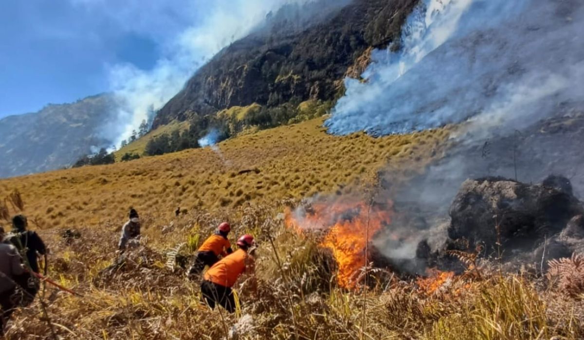
A total of 14 mountain areas in East Java have been reported to have experienced forest and land fires (karhutla) throughout the 2026 dry season. Among these dozen-plus locations, the Mount Bromo area in Probolinggo has become one of the sites with particularly severe damage.
The Chairman of the Operations Control Centre (Pusdalops) of the East Java Regional Disaster Management Agency (BPBD), Muhammad Amrul, confirmed that as of Wednesday (16/09), joint teams are still working to extinguish fires in five mountain areas, while nine others have been declared stable.
“Out of the 14 mountain areas, five are still undergoing handling and firefighting by joint teams. The remainder have been declared stable,” Amrul stated in Surabaya.
The 14 mountain areas affected by the fires include Mount Semeru, Mount Arjuno-Welirang, Mount Bromo, Mount Buthak, Mount Kawi Kajang, Mount Wilis, Mount Argopuro, Mount Ijen, Mount Raung, Mount Pegat, Mount Payaman, Mount Gede Blitar, Mount Ndangean, and Mount Lawu.
Currently, joint officers are prioritising efforts in the five mountains where the fires have not yet been fully extinguished, namely Mount Bromo, Mount Semeru, Mount Argopuro, Mount Kawi Kajang, and Mount Lawu. Conditions on the ground are reported to vary.
In the Mount Bromo and Mount Semeru areas, the impact of the fires is estimated to have reached 200 hectares. Although recent satellite imagery shows fire hotspots are beginning to subside, officers continue to conduct sweeps at the locations.
“Officers are continuing sweeps and wetting operations to anticipate the emergence of embers. The helicopter PK-DAP has also been prepared for observation, and if conditions permit, water bombing will be carried out,” Amrul explained.
Severe fires have also struck the Mount Argopuro area, which has recorded the burning of approximately 488 hectares of land since Saturday, 12 September 2026. Amrul revealed that the main obstacle to firefighting in this region is the location of the fire on extremely steep mountain slopes.
“Joint teams are monitoring Mount Gilap because the fire hotspot is located on a mountain slope that is inaccessible. Currently, the condition of Argopuro is covered in fog, so the fire points and smoke are not visible through visual monitoring,” he added.
Furthermore, firefighting efforts are also being focused on Mount Kawi Kajang (Blitar) and Mount Buthak (Malang). The total land burned in these two areas is estimated to reach 800 hectares.
For today’s operational plan, joint teams are scheduled to conduct sweeps via the hiking trail of Tulungrejo Village, Pujon Kidul District, and perform intensive monitoring up to Post 3 of Mount Buthak to ensure the fire does not spread further.
Mount Semeru experienced three eruptions on Monday morning (14/09/2026) with an ash column height of up to 1,000 metres. The status of Mount Semeru remains at Level III (Alert).
Forest fires in the Ijen Crater Tourism Area have begun to decrease. Joint teams are focusing on mopping up and aerial firefighting in difficult spots such as Mount Papak.
The East Java Provincial Government, through BPBD East Java, successfully implemented Weather Modification Operations (OMC) to tackle drought in 24 regions and reduce the risk of forest fires, resulting in rain falling in 11 locations.
BBKSDA East Java has temporarily closed the Ijen Crater Tourism Area due to forest fires spreading to the Pondok Bunder hiking trail. The closure is in effect until an unspecified time.
Firefighting at Mount Bromo is now being focused via land routes due to the challenges of strong winds and volcanic ash. All tourist routes have been completely closed.
Efforts to extinguish the fire in the Mount Bromo area via aerial operations using water bombing helicopters have been temporarily suspended.
The area of forest fire on the slopes of Mount Semeru has reached 600 hectares. Joint officers are focusing on manual firefighting and creating fire breaks to protect residents.
Joint teams are using drone technology and water bombing helicopters to tackle the Mount Bromo forest fires. The affected area has reached 1,120.3 hectares of vegetation.
BNPB aims for the total extinction of the Mount Bromo forest fires by Friday (14/08). The challenges of steep 80-degree terrain and limited water supplies are being addressed through water bombing.